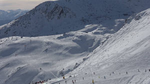
FORECAST World Heli Challenge Weekend

The helis will need good weather to fly. Image:: Harro
Forecast | By Aaron Cook – Mountainwatch.com Alpine Meteorologist
Summary:
On your marks: Get set: Wait. That’s likely to be the story for the World Heli Challenge’s first day of scheduled competition on Sunday as a good old fashioned West Coast rain event causes some early havoc.
There’s an absolute monster of a north-westerly on the way for the Southern Alps that is tailor made to dump huge amounts of rain on Mt Aspiring National Park. Keep an eye out for warnings and watches from the MetService.
The fly in the ointment will be freezing levels, which are going to rise too high for snow at first, but will then fall before the supply of rain is exhausted. This means terrain for the World Heli Challenge, which lies between about 1800 and 2000 metres, will see heavy rain on Sunday that could mess with the snow-pack, before some late snow reverses the damage.
The good news at this stage is that the models are showing a possible window of fine weather from Monday afternoon right through to Wednesday morning. It is touch-and-go whether cloud will clear in time on Monday, but Tuesday is looking very promising and is currently my favourite for the first day of competition.
Synoptic Outlook:
A low pressure system is going to breed off the coast of New South Wales on Saturday morning and absolutely fly across the Tasman Sea, doing the journey in just over day. Its central pressure will fall over 20hPa in that time. That sort of rapid development signals some very intense weather that should see northerly winds gusting over 100km/h in exposed parts of Mt Aspiring National Park on Sunday. I’m assuming everyone will be wrapped up warm in Wanaka on Sunday, but if not keep a very close eye on warnings from the MetService.
Saturday 31 July:
The low pressure system – the star of the show over the next two days – will be winding up in the western Tasman Sea as another trough of low pressure steams across the Southern Ocean to the south-west of New Zealand. Combined with a high pressure system centred east of the North Island, these features are going to bring a northerly flow to Mt Aspiring National Park which will result in cloud and light snow flurries that will intensify in the afternoon and turn to rain in the evening as freezing levels rise.
Sunday 1 August:
By early Sunday the low is more than halfway across the Tasman and bearing down on the South Island. Freezing levels will have risen to about 2400 metres, which will mean very heavy rain for the World Heli Challenge Terrain. Freezing levels then look likely to drop to below 2000 metres in the afternoon which should mean 10 to 20 centimetres of snow down to 1700m in the afternoon and evening*.
Monday 2 August:
The low exits stage-right early on Monday morning and a ridge of high pressure will form in its wake. Showers may hang around until lunchtime but by then the winds will have died down. A big question mark hangs over how much cloud will be lingering in the valleys, posing problems for competitors and pilots alike. If any skiing happens on this day it might be later in the afternoon, and it might all come down to how the weather interacts with the local terrain.
Tuesday 3 August:
Another broad area of low pressure in the Tasman takes a more northerly track which should leave Mt Aspiring National Park unscathed and experiencing mainly fine weather. Winds look to be light at this stage and if they can swing light easterly that would take care of the cloud too. This makes Tuesday the likely first day of competition at this stage, but bear in mind that a lot could change between now and then.
Extended Synoptic Outlook:
The models have a front approaching from the south-west on Wednesday and then another low pressure system on Thursday. This suggests we might lose two to three days to poor weather.
*As a rule of thumb, persistent snow can fall to about 300 metres below the free air freezing level before melting.