New Zealand Forecast, Monday August 14th – The Deep Freeze Continues While The Flakes Keep Falling
Mountainwatch | The Grasshopper
Written early Monday 14thAugust, valid to Thursday 17thAugust
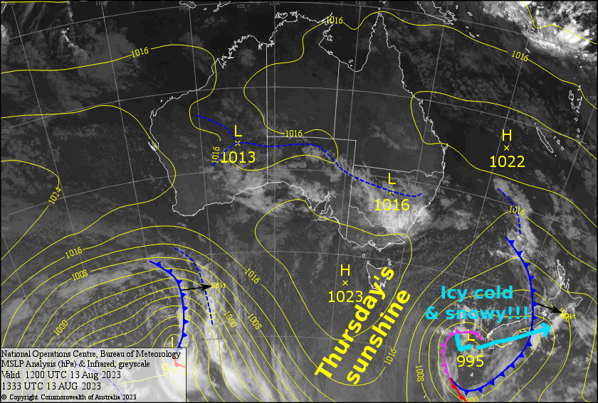
The next several days will remain icy cold here in NZ, as a low slowly crosses the South Island before drifting out east on Thursday. Cold air dredged up from the deep south will circulate around the low and cough up a couple of dustings for the Southern Lakes today and Tuesday, then a heartier top-up of about 5-15cm for Canterbury on Wednesday. Thursday will be “The Day”, with blue skies overhead and perfect snow underfoot.
Meanwhile, Ruapehu will likely rack up about 20-40cm of new snow after fairly persistent snowfalls there until early Thursday. However, it’ll start out wet on the lower slopes before snow levels start to drop significantly later this afternoon.
Snow will fall to low levels and icy conditions will affect many of the high roads around the country, so take it easy out there.
Monday 14th
A partly cloudy morning for the Southern Lakes, followed by a period of snowfall in the afternoon. About 2-5cm is expected to low levels, affecting the Crown Range road. Brisk N-NW winds will be icy cold, so wrap up warm.
Strong, cold NW winds over Canterbury, which may be up at gale force in exposed areas. There may also be a few snow flurries first thing, but the rest of the day will be fine apart from a little bit of cloud about the club fields further inland.
Snow falling on Ruapehu will progressively get heavier throughout the day while strong NW winds gradually abate. However, it’ll likely be wet on the lower slopes until snow levels start to drop later in the afternoon, then it’ll all clear up during the evening.
Tuesday 15th
Early morning snow showers over the Southern Lakes will clear around dawn, leaving just a skiff of new snow and partly cloudy skies while icy N-NW winds gradually ease.
In Canterbury, Mt Hutt will just see a little high cloud, while the club fields will see a bit more cloud at lower levels as well as a possible afternoon snow shower or two. Strong, cold NW winds will ease a little.
Ruapehu will start the day fine, but cloud will quickly build before snow showers get underway from late morning. Chilly NW winds pick up.
Wednesday 16th
It should be a fine day for the Southern Lakes, although low level cloud may affect the lower slopes if we’re unlucky. Cold S-SE winds.
Canterbury will have a cloudy morning, with a snow shower or two, before widespread, persistent snowfall gets underway during the afternoon as cold S-SW winds strengthen. About 5-15cm of snow is expected before clearing at night.
A few snow showers on Ruapehu before more serious, persistent snowfall from late morning. Snow levels start to drop even lower later in the afternoon as snowfall starts to ease, clearing overnight. NW winds will be strong up high.
Thursday 17th
Any morning cloud affecting South Island resorts will quickly clear to a blue bird day. Icy cold southerly winds, which will be stronger in Canterbury, gradually die out.
The odd lingering snow shower on Ruapehu will clear during the afternoon while fine spells increase. Snow and ice will likely affect the Desert Road. Brisk, cold SW winds ease a little.
Extended Forecast
Friday will remain fine over the country, but mild northerlies will pick up before a front brings just a skiff of snow to the South Island this weekend, but a heap of rain to Ruapehu on Sunday. Colder southerlies will thankfully see snow falling to lower levels on Ruapehu during next Monday. High pressure should provide a stunning day next Tuesday.
That’s all from me today, folks. See you again Friday.


