School Holiday SNOW STORM – 1m Forecast
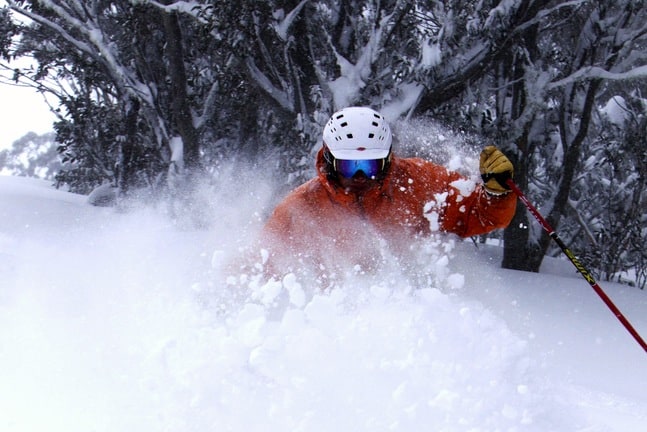
Faceshots at Hotham – could be likely at the end of the week. Image:: Mark Tsukasov/Hotham
Snowfalls | Tess Cook
The third significant snowfall of the 2011 season hit the Australian resorts early Monday morning, the beginning of a storm expected to deposit up to 1m of snow by the coming weekend.
“Freezing levels have now dropped and we’re going to see them around 1500m today and 1300m for the rest of the week, meaning snow to 1000m or even lower,” said The Grasshopper in the Monday forecast report. “That’s great for snow-making, and fantastic for all the snow that’s going to be rolling through. The models are forecasting half a metre or more over several days, with NSW resorts doing a little better.”
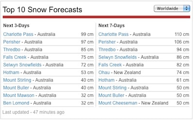
As the storm moves closer it appears to be gathering strength, with the predicted snow totals rising. On Monday Morning the forecast predicted 85cm at Perisher in the coming three days, by Monday afternoon the predicted total had risen to 97cm.
The brunt of the storm will hit on Tuesday and stay strong until Wednesday, with freezing levels dropping steadily. Wind speeds should hold steady at about 30km – 40km per hour in the resorts. Snow will continue to fall lightly into the weekend.
 “The coverage is good and getting better! It’s one of the best starts we’ve had in many years,” says Perisher’s Niel Thew. “We always want more fresh snow! It will mean a lot as it allows us to open more terrain as we head towards 100% of the resort open,” he says of the forecast snow storm.
Selwyn Snowfields’ Paul Chandler says the forecast snow will likely allow the resort to open 100 per cent of terrain, including the Tube Park. “This year is on par with last season. Last season was a record in visitation. New snowfalls should result in increased visitation and should set us up for the best season ever!”
While NSW fared better than Victoria in this season’s two previous snowfalls, Hotham and Falls Creek are both forecast to receive over half a metre of snow in this current storm.
“The snow is great news as we work to open more terrain such as Heavenly Valley,” says Hotham’s Gina Woodward. “We’re hoping that not only do we get the forecast snow but also some more opportunities to make snow and help build on the current base of 48cm in snowmaking areas. If we get the forecast 70cm+ then we can look towards more terrain opening also. Let’s see what Mother Nature gives us!
“The snowfalls are timely for the school holidays with lots of families in the resort,” says Debbie Howie PR Falls Creek. “We expect to open more terrain as the snow depth increases giving guests plenty of areas to explore.”
This run of snowfalls is a considerable contrast to the beginning of the school holidays in 2010, when little snow had fallen anywhere in Australia but a run of cold, clear weather had enabled almost non-stop snowmaking and every resort was sporting excellent coverage in the snowmkaing areas and almost no snow on the off piste runs.
However the weather has been a catch 22 at times, with rain damaging snow on the lower slopes and warmer weather hampering snowmkaing, while at the same time, especially in NSW, the June snowfalls have provided enough snow to open advanced and off piste terrain.
If this storm produces the amount of snow currently forecast, the Australian season will be looking very good indeed.
Perisher forecasts,
snow reports and
live snow cams.
Falls Creek forecasts,
snow reports and
live snow cams.
Mount Buller forecasts,
snow reports and
live snow cams.
Charlotte Pass forecasts,
snow reports and
live snow cams.
Hotham forecasts,
snow reports and
live snow cams.
Thredbo forecasts,
snow reports and
live snow cams.


