SEASON SNOW OUTLOOK – Japan
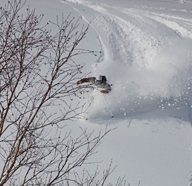
Charlie Timmins in Japan 2009. Image:: Ben Hansen
Forecast | ‘The Grasshopper’
Konichiwa. Welcome to the snow outlook for Japan this winter.
If you have read my earlier outlooks for the Western United States and Canada then you will know that a La Nina event in the eastern Pacific is the driving force behind the prospects for snow in Canada and the USA this winter. There is also some talk out there on the forums that La Nina could lead to more snow for Japanese resorts.
I am not going to repeat or criticise what has already been said, because we’re all in this together and I would hate to misrepresent anyone’s ideas. But I am going to argue that there is not enough evidence to make a claim either way. In other words, I will be trying to convince you that I have nothing useful to tell you about what sort of winter Japan can expect. But to keep you from running off to youtube to watch “baby monkey going backwards on a pig” again, I will explain why this is the case and show you a sexy weather photo to keep you reading.

Asia is a big place
For starters, during a La Nina, we do get higher atmospheric pressures over Siberia and Mongolia, which leads to more cold outbursts of northerly winds over eastern China. That sounds like a nice convenient trend to hang our hats on, but the problem is, the ski fields of Japan are a long, long way from eastern China, and from what I can tell they don’t see the same trend.
Figures 1 and 2 below back this up: In both graphs blues correspond to cooler than average temps during winter and you can see in both that the cooler temps are over China, but not Japan.
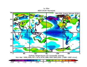
Figure 1: Winter temperature anomalies during La Nina. November to March
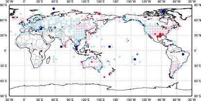
Figure 2: Temperature anomalies during La Nina. December to February
Furthermore, sea surface temperatures in the Sea of Japan are warmer than normal at the moment, as figure 3 below shows, and this should lead to warmer temperatures for Japan if anything.
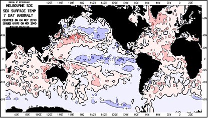
Figure 3: Sea surface temperature anomaly
So I’m confused about on what some people may be basing their claims for colder temperatures for Japan during La Nina. I’m very open-minded to other arguments though, so let us know if you have a different take.
Sea, lake, same difference
The next little gem that makes predicting Japan’s winter snowfall difficult is the much beloved lake effect. The ‘lake’ in this situation is the Sea of Japan, and the ‘effect’ is snow events so big you would think God was cleaning the dandruff from his comb.
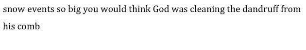
The lake effect occurs when extremely dry, cold air from the continent travels across the relatively warmer Sea of Japan. The air picks up moisture from the sea and is warmed at the same time. It then rises, transporting that moisture into the lower layers of the atmosphere. So then you have air that’s still pretty cold, but also very moist. Throw in a steep Japanese mountain range that causes this air to rise rapidly, and the result is snowfalls that regularly top one-metre in a day.
As the air travels across the water it also tends to organise itself into bands of convection, called cloud streets. These ‘streets’ may only be a few kilometres wide, which explains the fickle nature of snow in Japan. A mountain down the road can be getting dumped on and you could miss out.
Anyway, you can see an example of cloud streets below in an image that I would call weather porn. But this is where things get complex. For these streets to form you need the atmosphere to be just right.
First, the air needs to be colder than the sea surface. The cold air off the continent is perfect for this.
Second, you need a good long body of water so the air has time to pick up the moisture. Tick. The Sea of Japan is plenty wide enough.
Third, you need an inversion layer about three kilometres up in the atmosphere. This is an area where it starts to get warmer with height, and it keeps a lid on the convection, trapping all that moisture close to the earth.
Lastly, you need the wind to be a fairly steady speed and direction all the way up to the inversion, otherwise it will mess up all of your lovely organised cloud.
Figure 4: Cloud Streets over the Sea of Japan
That’s enough physics for today
The lake effect, as you have just seen, is a complex beast. But you can be confident that in any one year you are going to get a couple of instances of it. Let’s face it, many fields in Japan get so much snow that your only worries occur early and late in the season. And I see nothing to tell you that you should worry about this year being any different.
But because of the complexity of snowfall in Japan, I think it is simplistic to say that stronger winds and colder temperatures, even if they did occur, will lead to better snowfall. You also have to factor in the sea surface temperatures, whether or not there is an inversion, and whether the winds are steady with height.
All these are essential to the cloud streets that could make or break a season, and they are very short term phenomena. There just has not been enough research to speculate how a climactic event like La Nina is going to affect all of these variables and they way they interact.
So book a holiday and go
The answer is: there is no answer. But the skiing in Japan this winter will most likely be amazing anyway. So what are you waiting for?
Hakuba forecasts,
snow reports and
live snow cams.
Niseko forecasts,
snow reports and
live snow cams.


