SNOW SEASON OUTLOOK 2013 – Australia – UPDATE
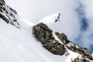
Aussie skiers are holding their breath to find out if this season will deliver days like this Image:: Courtesy of Thredbo
Australian Seasonal Snow Outlook | The Grasshopper
Brought to you by ESS Boardstores
Where the heck did April go? It feels like about two days ago that we published our first seasonal outlook of the season and then, before we could say “early season snow”, it was May already, and we find ourselves less than 6 weeks from the opening weekend of the season.
We saw a notable amount of snow for April across the Aussie Alps. Let me be clear that I don’t think this means anything for the season either way. Sometimes we hear the argument that early snow cools the ground to give future falls and snow-making a better chance of hanging around. While that might be true of something in mid-to-late May, after the last few days of strong winds I think the effect of the April snowfalls is well and truly gone and we’ll be starting from scratch near the end of this month.
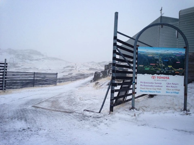
The early snow we received on April 19, now a distant memory Image:: Courtesy of Thredbo
The new black
Last month I talked about how neutral ENSO conditions were forecast to be all the rage this winter. That hasn’t changed in the last five weeks, with temperature anomalies in the equatorial Pacific threatening to flat-line for the next few months.
As with last month, if there’s anything different from normal it’s warmer sea surface temperatures around Australia. This can add a bit more juice to weather systems, meaning slightly enhanced rain, but it also means warmer temperatures, so it’s hard to confidently link the sea surface temperature effect to any effect on snowfall.
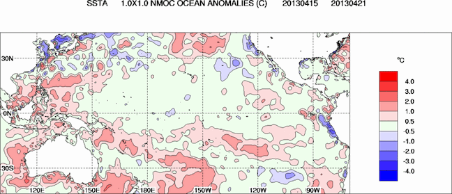
Temperatures across large parts of the equatorial Pacific are within 0.5 degrees of normal, but there’s a nice warm patch around Australia. Source: Bureau of Meteorology
More neutral than Switzerland
A neutral year isn’t necessarily bad news, as neutral winters have averaged about 20cm more snow than La Ninas or El Ninos at Spencers Creek in the Snowy Mountains (still waiting on that Victorian data Hotham and Falls folk). But this NSW average is skewed by some pretty crazy totals from years that saw a bunch of cold fronts rear up over the resorts to deliver the goods. This winter climate models are leaning more towards lower pressures across the continent and into the Bight, with a band of higher than average pressures stretching through the oceans south of Australia and New Zealand.
The combined effect of this pattern is that we’re likely to see weaker or less frequent westerlies on average, and when we do get rain features coming through they are more likely to be unpredictable low pressure systems that turn the Aussie Alps into a big spinning cauldron, mixing warm, moist air from the north and cold dry air from the south. In these situations there’s nothing you can do but hope that it’s cold enough by the time it starts dumping over your resort and that it pisses with rain over somebody else. I imagine there are going to be some tough calls to make this year whether we’ll see rain or snow for individual events and I’m sure I’ll get a few wrong. Terrain elevation will be as important than ever.
By the numbers
With forecasts of neutral conditions persisting I see no reason to change my forecast from last month, which remains:
- Spencer’s Creek to break one metre snow depth in the first week of August and to top out at 171cm in late-August.
- June to see a slow start, with the first big snow storm (40cm+) in early July.
But be warned. If I see any further evidence that we’re not going to get enough westerly wind action this winter I may be forced to trim this outlook back when we update in late-May. Last year it was our late-May update when we correctly predicted that 2012 would be the first year since 2004 to bust the 200cm mark. If you’ve got a different theory on what’s going to happen this winter then please hit me up at grasshoppermw@gmail.com or join the discussion via Facebook below.

Perisher forecasts,
snow reports and
live snow cams.
Falls Creek forecasts,
snow reports and
live snow cams.
Mount Buller forecasts,
snow reports and
live snow cams.
Charlotte Pass forecasts,
snow reports and
live snow cams.
Hotham forecasts,
snow reports and
live snow cams.
Thredbo forecasts,
snow reports and
live snow cams.
Mount Baw Baw forecasts,
snow reports and
live snow cams.