2018 Australian Snow Season Outlook – June Update

CLIMATE DRIVERS STILL NEUTRAL & MODELS SITTING ON THE FENCE
Mountainwatch | The Grasshopper
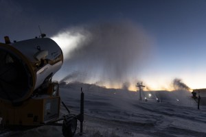
May has certainly been a month of feast and famine. Like little piggies, we gobbled up a three-day banquet of snowfall from May 10-12. Only a patchy, slushy layer at higher elevations serves as a reminder of the glut, the rest has either melted or been washed away by evil rain.
The past week or so has seen a big dirty high lumbering over the Australian Alps, starving us of any real snowfall, while providing the Kiwis with a banquet of their own. New Zealand has certainly prospered from being on the right side of the high with cold south-westerlies dumping 50-70 cm or more on ski fields in the Southern Lakes District this past week, locking in a solid base for our Kiwi mates on opening day.
The big high finally over the ditch last week and the Aussie Alps received a couple of light dustings of a few centimetres at the major resorts, and we should see a window for the snowmakers to fire up the guns this week. There may also be another dusting around opening weekend, June 9-10, but I will delve into more detail about all this in my Opening Weekend Outlook that I’ll issue on June 7. Despite how much snow will be lying on the ground, opening weekend is going to be awesome. If you haven’t already planned which resort to go party at, check out the Mountainwatch guide to opening weekend to find out what’s going on.
Let’s now look further ahead and see what the climate drivers can tell us about the upcoming season, and whether anything has changed in the last month. In case you missed the April or May outlooks; you can find them here and here.
ENSO, IOD & SAM
First and foremost, a neutral phase of the El Niño Southern Oscillation (ENSO) is still likely to reign supreme this season. Some models suggest El Niño thresholds could be reached sometime during spring. If El Niño does rear its ugly head, it’s likely to be a weak one and its influence on Australian snowfall should be small. This is good news because on the whole, neutral years are generous to the Australian Alps, whereas El Niño’s are stingy with the snow.
The Indian Ocean Dipole (IOD) still remains neutral and looks set to stay that way. There is now less chance of seeing a negative IOD this season from a month ago, which is disappointing as a negative IOD can feed moisture into fronts as the cross the Aussie Alp, beefing up the precipitation which hopefully falls as snow.
On the flip side, there is stuff-all chance of seeing a positive IOD. Consequently, the IOD isn’t likely to help or hinder snowfall this season.
The Southern Annular Mode (SAM) is currently negative, but is forecast to approach positive in the first week of June. This means that all those juicy storm systems and cold Antarctic air will slink off further south, away from the Aussie Alps. Therefore, we’re less likely to see any big snowfalls during the first couple of weeks of June. I’m not too worried because some of the best seasons had poor snowfalls during June, while some of the worst seasons had big early falls.
CLIMATE MODELS
Climate models are complex beasts, but they are really handy when trying to decide how a snow season will play out. Climate models attempt to marry up the relationship between the ocean and atmosphere, thereby intrinsically taking into account climate drivers, such as the ENSO, IOD and local sea surface temperatures (SST).
Every time I forecast, I need to juggle a vast array of climate model data from different independent sources. When looking at Australia for example, the major sources of model data that I use are those provided by the ECMWF, UKMO, NOAA and the BOM. These acronyms are enough to make you dizzy, and I’m not going to spell them out here, but get familiar with them because they are the big dogs on the scene. Luckily, there are a number of “super-duper” models out there that bring all of these independent models together and spits out a nice average between them.
In most cases, these super-duper models provide better and more reliable seasonal forecasts. The reason for this is because each independent model has its own inaccuracies, which tend to throw the forecast off course, especially when compounded over long-range seasonal forecasts. By taking an average between models, some of these errors are reduced, giving us a better result.
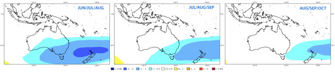
The image above is from the C3S super-duper model, which collates data from the ECMWF, UKMO and Météo-France. Here, the C3S is showing that low-pressure anomalies extend over southeast Australia, the Tasman Sea and the North Island of New Zealand, which gradually weakens and migrates eastwards during the season. This is consistent with previous model runs, which gives us more confidence in this scenario coming to fruition. So, we should see plenty of storm action over the Aussie Alps, as well as the Tasman Sea, especially during the first half of the season.
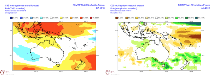
Similar to last month’s outlook, precipitation and temperature anomaly charts are still giving me the old blank white, 50:50 scenario. This means we’re faced with an equal chance of above or below median precipitation and temps, so there’s no real push in either direction of a good or bad snow season. We should expect this considering we have neutral climate drivers. One thing we can say is that these variables are likely to lie within the middle 50%, i.e. between the 25 and 75 percentiles, rather than lying at an extreme end.
Only when looking at the individual BOM and ECMWF models do I find a push towards warmer temperatures during the winter months. This is likely due to warmer SST in the Tasman Sea and certainly causes me to frown a little. Combining this idea with the low-pressure pattern, we could see more lows in the Tasman Sea of a warmer air-mass directing rather wet slushy snow, if not outright rain, from the southeast. However, as I’m taking all models into consideration, I won’t sound the alarm just yet.
SUMMARY
Climate drivers are still cruising along in neutral and models remain sitting on the fence. As I’ve mentioned before, a classic neutral ENSO pattern is good news for Aussie snow. I am worried however, that increased storm activity in the Tasman Sea could be of the warmer variety and make rain more likely than snow in the Aussie Alps. There is the threat of a weak El Niño developing during spring, but this shouldn’t make or break the season. A negative IOD is looking less likely, so we can’t count on this giving us a leg up at this stage. This season is still very much up in the air, and the chaotic nature of the weather is likely to play a bigger part.
For this outlook, I’m going to slightly fine-tune my predictions away from the optimistic end of the scale. I still foresee that the first half of the season will be pretty good and that we’ll have a slight slowdown during spring. Maximum snow depths should lie within a range of 180-210 cm when comparing to a long-term average of 195 cm at Spencer’s Creek. So, on the whole, we’re in for a decent season.
Hopefully I have shed some light on the coming season or at least provided you some fodder to mull over. I’ll update this outlook at the beginning of July as the business end of the season kicks off. If you’ve got a different theory on what’s going to happen this winter, or just want to provide feedback, then please hit me up on the discussion below. Or you can follow me on Facebook.
Sign up to receive the latest news from The Grasshopper!