Snow Season Outlook 2015 – August Update – New Zealand
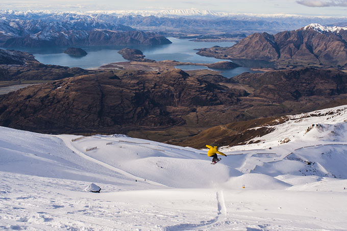
Treble Cone is close enough to the divide to make the most of the northerly feeds, yet well-exposed to the southerly storms too. Will Jackways finds a little airtime on a recent TC powder day Image:: Johnny McCormack
New Zealand Seasonal Snow Outlook | The Grasshopper
Brought to you by ESS Boardstores
There’s no sense sticking our head in the sand, 2015 is a strong El-Nino year – in fact, it’s forecast to strengthen next month.
The weather doesn’t always like to play ball. We got stuck into an anomalous weather pattern from the second half of July – everything shifted west. The high went on holiday to Perth and those lows were also spinning further west than we would have wanted. You can read more about this pressure pattern in my August forecast for Australia. This synoptic configuration meant that the westerlies we would have expected in an El Nino year were more frequently northerly or north-westerly in nature. We fared ok throughout June, but while the Aussie Alps have been getting hammered with decent snow for the last few weeks, we’ve been sitting on the wrong side of that low. It’s been throwing front after front our way with the Southern Alps eating up hit after hit of moisture from the North.
The problem with northerlies – if you aren’t riding Mt. Cook or Mt. Aspiring – is that most of the Canterbury resorts sit in the rain shadow of the divide. This means that most of the clubbies haven’t seen too much snow while that feed is coming from the north.
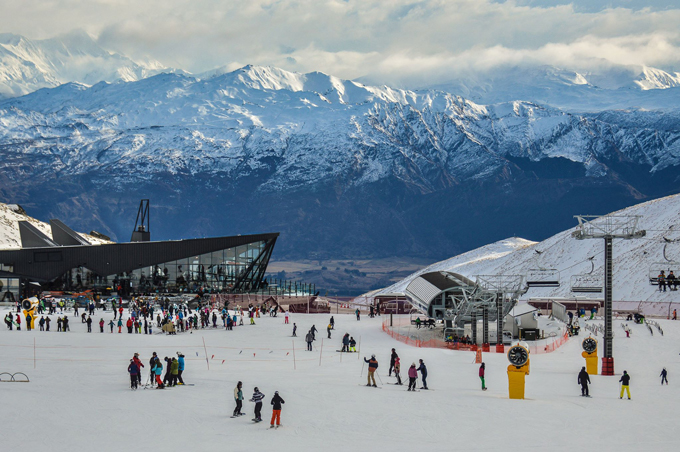
Coronet Peak looking fabulous. With more snow coming this week things are really shaping up for the Southern Lakes Image:: NZSki
Got any figures on that?
Currently leading the table for highest base snow depths in the country are Treble Cone and Cardona – both near Wanaka – with a respectable 248cm and 250cm base on the higher slopes. Note that the base depth in Treble Cone is only 91cm down low, which shows how altitude is crucial in this kind of flow. Whakapapa and Turoa aren’t doing too bad either with 145 cm and 165 cm respectively. All of these resorts aren’t effected so much by the rain shadow. Compare these bases with the 105cm base in Mt Hutt and you get the picture.
Looking Ahead
In the short term, the first week of August sees the best snow potential in Wanaka and the Southern Lakes as a low out in the Tasman zips over the region. Then, the models are in good agreement that we will see a significant cold outbreak from August 7 to 12. This will bring falls back to resorts that have missed out in July. I wouldn’t rule out another big dump in Canterbury resorts during this timeframe.
Beyond August 12, northerlies will develop for a time as another low approaches from the south-west before the westerlies return. It is then likely that we’ll stay in a more westerly pattern until the end of the month which will give us a few frequent top-ups of fresh snow.
July has been a bit of a mixed bag, with winners and losers depending on your location relative to a more frequent north or north-westerly flow. I’d expect that in August we will see more winners than losers as we shake off that anomalous weather pattern which dominated the second half of July. The larger scale climatic drivers stay the same as in previous forecasts – it is likely we will have more westerlies with a southerly/south-west element to them averaged out over the whole month. This will see greater snowfall amounts in August compared with July for Canterbury.
The Remarks opened a new base building just in time for a bumper season. That view ain’t bad either Image:: NZSki
Ruapheu will continue to build on its’ solid base once it gets past a wet couple of days early this week. Wanaka has done well out of the northerlies with frequent top ups from the fronts which have been slamming into the South Island in recent weeks. The models indicate that we will have at least one significant cold spell this month from the 7th of August which should deliver for all. The Southern Lakes region could do especially well out of it.
That’s all from the Grasshopper. We’ll update this outlook in early September. If you’ve got a different theory on what’s going to happen this winter, or just want to provide feedback, then please hit me up on the discussion below. Or you can follow me on facebook.
SIGN UP TO THE GRASSHOPPER’S AUS/NZ WEEKEND FORECAST:

The Remarkables forecasts,
snow reports and
live snow cams.
Treble Cone forecasts,
snow reports and
live snow cams.
Cardrona forecasts,
snow reports and
live snow cams.
Turoa forecasts,
snow reports and
live snow cams.
Coronet Peak forecasts,
snow reports and
live snow cams.
Whakapapa forecasts,
snow reports and
live snow cams.
Mount Hutt forecasts,
snow reports and
live snow cams.


