2018 Australian Snow Season Outlook – July Update
Mountainwatch | The Grasshopper
A FAST START, BUT SIGNS ARE POINTING TO A SLOW DOWN
After a fruitful June, the slopes are looking as healthy as ever with Spencer’s Creek recording a snow depth of about 70cm, which is one of the best starts we’ve had for a long time.
That’s mostly thanks to the Season Starter Storm we had in mid June that dropped 70-100cm over a six day period. This all comes despite June ending up warmer and drier than average… huh, no way! Added to that, clear nights and low overnight temperatures have seen snow machines bolster snow depths on main trails. Last weekend we had another little top up of 5-10cms and an even more intense storm is looking likely this coming weekend with snow accumulations of 20-30cm or more possible. I’ll elaborate more on this storm in the days to come in my daily forecasts. Let’s now look further ahead to see if this dream run will continue.
ENSO, IOD & SAM
The El Niño Southern Oscillation (ENSO) is still in a neutral phase. Sea surface temperatures (SST) in eastern-central areas of the equatorial Pacific Ocean have warmed over the last month and are now looking rather tepid. These waters are likely to continue this warming trend, with El Niño thresholds now favoured to be reached sometime in Spring, most likely during October or November. By then however, the Australian snow season will be in it’s final throes and any snow on the ground would have largely been influenced by a neutral ENSO.
This is great news because, on average, neutral years provide good snow depths and a large number of skiable days. El Niño’s on the other hand are quite the opposite, resulting in some of our poorest seasons. If last year was anything to go by, we can still see hefty snowfalls during September. The ENSO typically exerts its most influence on Australian snowfall at this tail end of the season, so fingers crossed that El Niño does indeed hold off until at least October.
The Indian Ocean Dipole (IOD) is still ticking along in neutral and looks set to stay that way throughout the season. Consequently, the IOD isn’t likely to help or hinder snowfall this season.
The Southern Annular Mode (SAM) has been negative since around mid-June, which may be indicative of the 70-100cm of snow that fell during this time in the Season Starter Storm. SAM should approach neutral values over the next week. From then on models are really all over the show, which unfortunately doesn’t provide us with much insight. If you cross your ski’s next time you’re heading up the chair lift, then Sam might just bounce back negative and grace us with his snowy goodness.
CLIMATE MODELS
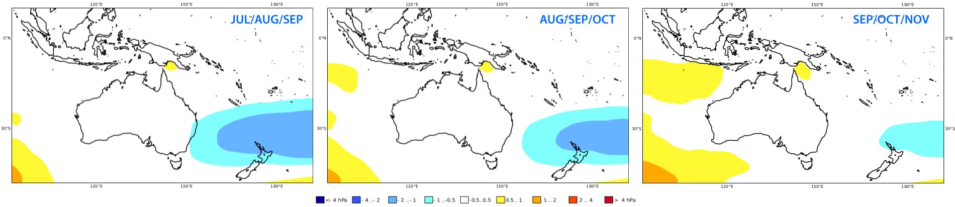
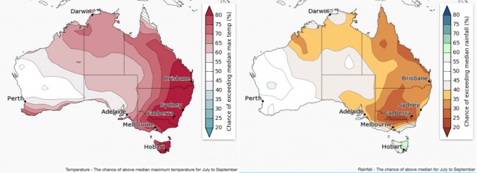
The C3S model shows a similar pattern to previous forecasts, but low pressure anomalies have been pulled away from southeast Australia, indicating there may be less storm activity than initially thought. Lower than average pressure is still expected in the Tasman Sea, but storminess in this area is unlikely to aid snowfall in the Aussie Alps. The BOM, as well as some individual models, are picking higher than average pressures to the south of Australia, resulting in weaker westerlies and fewer cold fronts gracing our beautiful slopes, darn it.
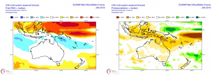
The C3S is still not pushing temperatures towards either end of the thermometer, but it’s now showing the next three months could be drier. The BOM’s outlook is even more foreboding, as it is really gunning for the next three months to be warm and dry in the Aussie Alps.
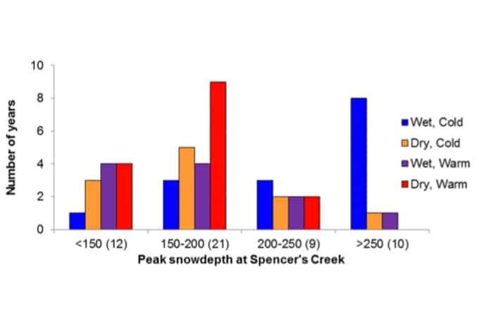
All is not lost however, because the great start to the season we’ve had comes despite June ending up drier and warmer than average. This is rather counterintuitive but highlights the fact that snowfall in alpine regions is complex. In fact, there are plenty of warm dry seasons that end up with average or above average snow depths, although they are not likely to go down in history as being epic.
SUMMARY
Climate drivers are still cruising along in neutral, but El Niño is threatening the tail end of the season. The great start to the season can also mean that the season doesn’t finish well, and there are a heap of years that this has happened. Models aren’t looking promising either, as we’re likely to be warm and dry in the Aussie Alps. However, there are plenty of warm dry seasons that get average or above average snowfalls, and weather regimes are looking more variable than usual this season, i.e. long settled periods interrupted by intense storms with good snowfalls. This could give us the best of both worlds, with pretty good snow depths as well as bluebird days to enjoy it. It may also mean that long settled periods provide plenty of freezing clear nights for the snow machines to work their magic.
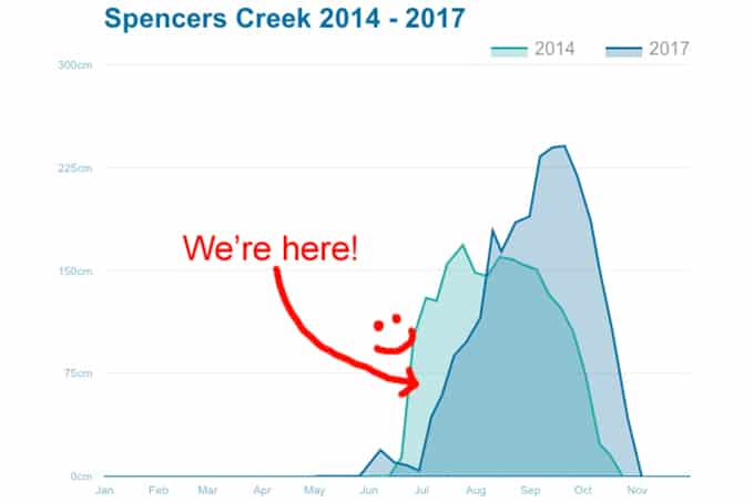
For this outlook, I’m going to slightly pull my predictions away from the optimistic end of the scale again. I’m expecting this season is going to look a little more like 2014 rather than 2017, where the front end of the season is great, but slows down during spring, with overall snow depths about average or even slightly under. Let’s say 175-200 cm when comparing to an average of 195 cm at Spencer’s Creek. That’s not a pessimistic outlook by any means, and with snow depths already looking healthy with more on the way, this season should be a success.
Hopefully I have shed some light on the remainder of the season or at least provided you some fodder to mull over. I’ll update this outlook at the beginning of August while we’re waist deep in powder.
If you’ve got a different theory on what’s going to happen this winter, or just want to provide feedback, then please hit me up on the discussion below. Or you can follow me on The Grasshopper’s Facebook.
Also check in daily throughout July and August as I’m issuing daily synoptic outlooks, breaking down the following week and providing a more concise extended outlook – for both Australia and New Zealand. You can follow my daily forecasts here!