2018 New Zealand Snow Season Outlook

Want to learn more about snow forecasting? Download the FREE ‘Grasshoppers Guide To Snow Forecasting’ by filling out the information below… 16 pages of snow forecasting gold: how to read charts, typical snow systems, the when, where and why of snow forecasting and a full glossary of A-Z weather definitions.
Climate drivers and models pointing to below average conditions this season, but a stormy Tasman Sea might put paid to that.
Mountainwatch | The Grasshopper
After the hottest summer on record and a well-above-average March, the cold season has abruptly burst onto the scene in Aotearoa, New Zealand. Temperatures were being fuelled by the marine heat wave in the Tasman Sea, as well as by frequent tropical northerly winds courtesy of the weak La Niña in the Pacific Ocean. But then a full-on winter storm pounded the country on the 10th of April, with snow falling down to 700m in the North Island, and 300m in the South Island. Mt Hutt had a dumping of half a metre of snow. Temperatures have been below average since that storm, with mercury levels consistently dropping down to low single and even minus digits at dawn. Another 20-30cm or more over the South Island this weekend (28-29th April) will put more icing on the cake. Will this preseason dream run continue?
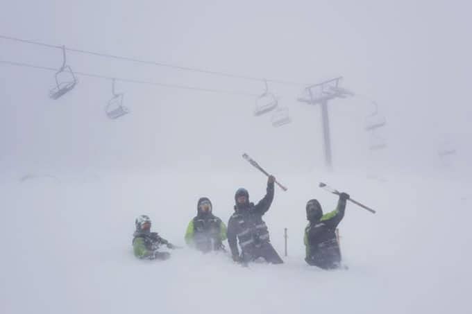
More epic snowfalls like we had on the 10th of April would be nice. The maintenance crew, loving it on the upper slopes of Turoa.
Being the first outlook for New Zealand this year, I will delve into some of the nitty-gritty behind major climate drivers. So, if you just want the juicy details without all the science mumbo-jumbo, then scroll to the summary at the bottom. For the rest of you, light the fire, sit back and enjoy.
A neutral ENSO, but are we heading for a wrong’un?
The first thing to know is that we’re likely to be playing to the beat of a neutral El Niño Southern Oscillation (ENSO) this season, although possibly one with the slight upbeat tempo of a weak El Niño right before the rotund snowman sings.
Essentially, the ENSO represents the differences in sea surface temperatures (SST) between the east and west of the Pacific Ocean near the equator. Warm water can slosh from side to side in this massive bathtub and have far-reaching influences on weather patterns around the globe. A neutral ENSO means that SST are near climatological normalcy, whereas an El Niño represents warm anomalies in the east and cold anomalies in the west. La Niña is simply the opposite of El Nino – cold SST in the east and warm in the west.
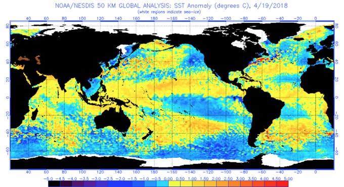
SST around the equator of the eastern Pacific Ocean are still slightly warm in the west and cool in the east, but lie within a neutral state of the ENSO. Waters around New Zealand are still above average for this time of year. Source: NOAA
SST surrounding the equator are still a bit chilly in the eastern Pacific, but they lie within the neutral range of the ENSO. Warm water below the surface has pushed its way east under these chilly waters and will start to rise to the surface over the next couple of months, further dissipating any remnants of the weak La Niña we had over summer. Climate models all agree that these waters will continue warming through winter and spring, with a 50-50 chance of reaching El Niño status by mid to late spring. This could add a nice crescendo to the end of the season, or it could come a little too late and just be downright awkward – like singing another verse once the song has finished. If El Niño status is reached, it’s likely to be a weak one and it’s influence will be small.
EL Niño’s are generally rubbish for the Australian Alps, but they’re “sweet as” for NZ. ENSO has less influence on NZ’s weather than Australia’s, and it accounts for less than 25% of year-to-year variance. That being said, El Niño’s have a tendency to increase pressure over southeast Aussie and decrease pressure to the southeast of NZ. This opens the door for more incursions of colder air from the south during winter, and brings stormier springs with more frequent southwest winds.
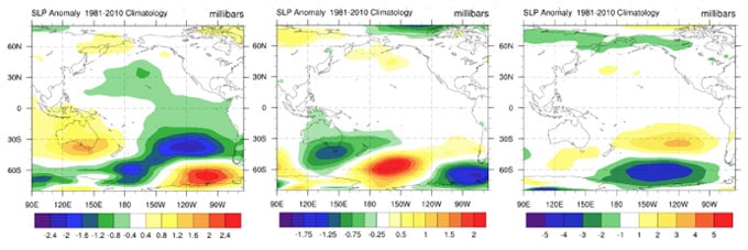
Climatological comparison of June-September sea level pressure anomalies between ENSO phases as determined by the Australian Bureau of Meteorology. El Niño (left), neutral (middle) and La Niña (right). Source: NCEP
Neutral years vary wildly, but on the whole, they look somewhat opposite to El Niño’s – anomalous low pressure over southeast Aussie and higher pressure to the southeast of NZ. This gives us a greater likelihood of warm east to northeast winds and less probability of seeing colder air from the south to southwest. In other words, not an ideal setup for snowfall. As I’ve mentioned in previous outlooks, neutral years have their wrong’uns, which buck the trend to give more favourable pressure patterns. The years 1980 and 1992 are good examples.
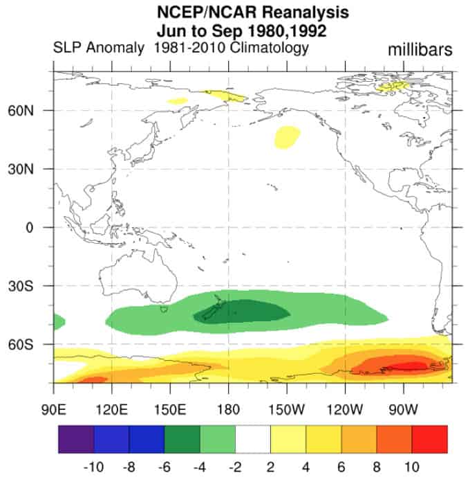
Neutral wrong’uns buck the trend to offer more favourable pressure patterns. 1980 and 1992 saw plenty of lows to the east of the South Island driving up cold southerlies with a bounty of snow. Source: NCEP
So, considering we have a neutral ENSO that is gradually trending towards a weak El Niño, there is the faint hope that we may be heading for a wrong’un, especially during the spring end of the season. The storm that hit Middle Earth on the 10th April was a typical neutral wrong’un scenario. In the day or two leading up to the storm, cold air had swept up the country, thanks to a passing cyclone to the southeast. A low then deepened as it rolled east over Tasmania, the Tasman Sea and central New Zealand – a path that is more typical in neutral years. The low brought warm air with abundant moisture, while cold southerlies east of the Main Divide undercut it to ensure the snow stayed frozen as it reached the ground. This phenomenon is known in the business as “overrunning”, and is perfect for getting phat stacks of the white stuff, especially in Canterbury. On this occasion, Mt Hutt got an impressive 50cm. Ski fields outside of Canterbury received 15-20cm, which is better than a kick in the pants, but is a reminder of how location is everything in Aotearoa.
It is likely we will see more lows take a similar path this season, but in order to make the most of them, we need the cold southerlies to create this overrunning effect.
SAM – The life of the party
One of the most influential climate indicators that could provide the push we need to take this neutral season to great heights is the Southern Annular Mode. This is the big boy of the Southern Hemisphere, and goes by the nickname SAM. For those of you who missed my Australian outlook last month, I’ll re-introduce SAM to you.
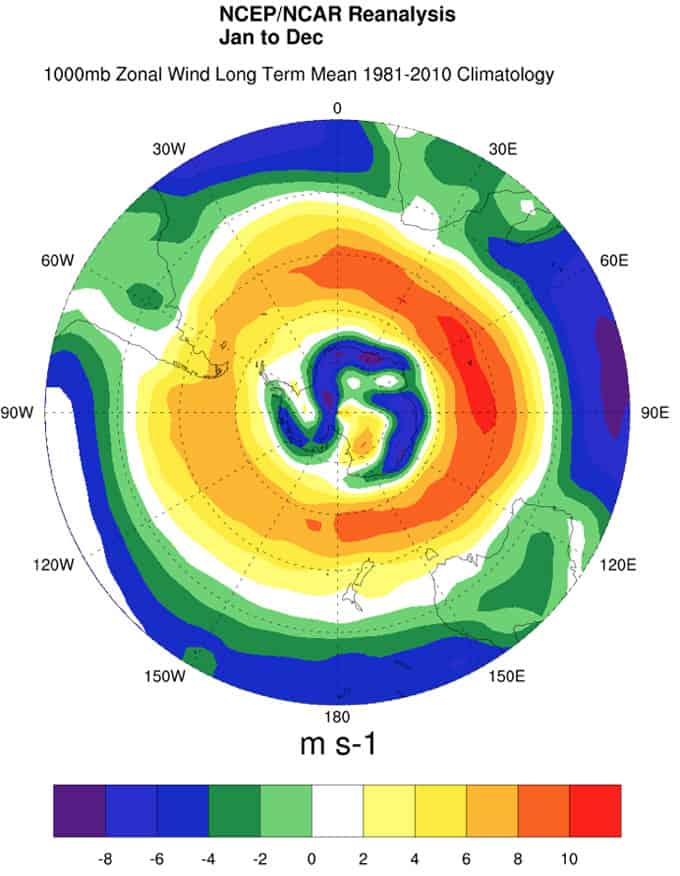
A bird’s eye view of the South Pole showing the climatological speed of zonal winds. The ring of orange indicates the belt of strong westerlies that whip around the Southern Ocean. The Southern Annular Mode (SAM) is related to the north/south position of these westerlies.
SAM is able to muscle the north/south position of the belt of westerly winds whipping around the Southern Ocean. This belt marks the boundary between icy air over Antarctica and warmer air of the mid-latitudes. Storm systems lie within this belt, and a negative SAM brings them north to batter New Zealand’s Alps, delivering lower temperatures and healthy doses of snow. A positive SAM has the opposite effect by pulling the westerly belt further south.
Responses to SAM are more prominent about and west of NZ’s Main Divide. The effects on eastern areas are much less clear-cut, and tend to be small. However, a negative SAM can turn a measly low from the Tasman Sea into a real humdinger by bringing in the cold air that is necessary for overrunning. This causes the low to cough up the goods and deliver copious amounts of snow to eastern areas.
Unfortunately, we can only forecast SAM up to two weeks out, and about 30% of snow seasons experience both positive and negative phases. The current negative phase is only expected to last until the start of May before flipping positive. The climate model run by the National Oceanic and Atmospheric Administration (NOAA) shows zonal winds (westerlies) to be weaker over NZ throughout the entire season, and generally stronger to the south, suggesting that SAM might not come back. This doesn’t tell the whole story however, and SAM is less predictable than that. So we can still keep our ski poles crossed that the big boy will make a grand return and get this party started.
SST – Warm as bro
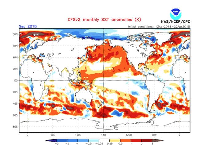
SST are likely to be trending towards these September anomalies through the season. Waters are still expected to be warmer southeast of New Zealand in September, with pockets of warm water remaining in the Tasman Sea.
Although the marine heat wave in the Tasman Sea has cooled off a bit, SST are still above average. Temperatures should continue approaching normal levels through the season, but pockets of warm will remain as the image above indicates. This should all push average temperatures up for at least the first half of the season.
Warm anomalies predicted for large parts of the Southern Ocean are a little concerning, because this is where the bulk of our storm systems come from. Warmer waters should add some juice to these systems, but it may also lift the snowline. I won’t cry into my Weetbix just yet though, because I’ve seen this pattern a million times and it may be due to the global trend of warming oceans. Ditto for the warm anomaly off southeast Australia. Here the East Australian Current has expanded southwards over the last half century or so, lifting SST by about 2°C on average.
Climate Models
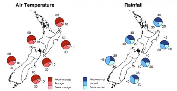
NIWA’s climate outlook for April-June indicates there might be a few sad faces when ski resorts open mid June.
No seasonal outlook would be noteworthy if it didn’t include a thorough dressing-down of climate models. The first port of call is Aotearoa’s very own National Institute of Water and Atmospheric Research (NIWA), who have issued a three- month outlook to the end of June. This should give us a good indication of conditions leading up to opening day, as well as the first couple of weeks of the season. Even though La Niña’s influence is waning, the climate is still expected to be largely driven by the persistence of more northeasterly winds and warm SST. Consequently, NIWA expect higher than average temperatures for the whole country, which means, dare I say it, rain could be more likely, especially at the base of ski fields. It could also mean that the snow that does fall has higher moisture content, thus negatively affecting snowpack. Precipitation (rain or snow) is expected to be average or above average for Mt Ruapehu’s ski fields and most likely average for South Island fields.
The recent cold temperatures have been a slight detour on NIWA’s April-June forecast, but when SAM flips positive at the start of May, we’re likely to see it get back on track. Major climate models mostly agree with NIWA’s outlook, but they appear to want less precipitation for South Island ski fields during May. Models also hint that the lower South Island should be relatively settled, especially compared to the North Island. Although average temperatures are likely to be warm, snow machines in Canterbury, Wanaka and Queenstown should be able to stretch their legs during clear clam nights. Artificial snowmaking is likely to be hampered in the North Island due to warm temps, storminess and increased rainfall.
From July onwards, climate models are in remarkably good agreement. They show the general pattern that we would expect during a real-McCoy neutral ENSO. Low-pressure anomalies stretch from southeast Australia, across the Tasman Sea and over the North Island. Higher than normal pressure lies to the southeast of New Zealand. This indicates anomalous east-northeast wind flows, like we talked about earlier. Warm temperature anomalies should continue through much of the season, with the signal more convincing over the lower South Island. Precipitation too is what we would expect during a neutral season, with above average falls in the north of both islands and below average for ski fields in Canterbury and the Southern Lakes District. This all adds up to a bad omen and things don’t look favourable for a wrong’un. I’m not too rattled at this stage however, because model uncertainty is at its highest this time of year and they have been know to get it completely wrong.
Summary
To cut a long story short, the odds are stacked in favour of a classic neutral ENSO pattern for at least the first half of the season. That is, anomalous east-northeast wind-flow, warmer temperatures, and less precipitation for ski fields in Canterbury, Wanaka and Queenstown. Average or above precipitation is expected for ski fields in the upper South Island and on Mt Ruapehu, which is likely to fall as rain during the preseason, but will hopefully turn to snow as temperatures drop later on.
So, I’m predicting a few sad faces on opening day, not really sad, just disappointment at below average conditions. This is likely to continue at least throughout the first half of the season. One saving grace is that the Tasman Sea should be more unsettled than usual. Although we’re not likely to see as many snow storms hitting us from the south, one or two well-placed storms from the Tasman Sea with overrunning could buck the trend and turn those frowns upside-down. These events will be zero to hero, and you’ll need to be Johnny-on-the-spot to score the bonanza. I’m optimistic that the second half of the season will pick up some of the slack, but we have to mentally prepare ourselves for an overall below average season.
Despite the prognosis not being overly fantastic, New Zealand will still see a healthy mix of highs and fronts dance by over the course of the season, and you can almost be guaranteed there will be ample opportunity to get your slide on.
That’s it from me guys. I’ll update this outlook at the beginning of June as the excitement becomes unbearable. If you’ve got a different theory on what’s going to happen this winter, or just want to provide feedback, then please hit me up on the discussion below. Or you can follow me on Facebook.
Grasshopper.
Did you know?
A lesser-known fact about the mysterious Grasshopper is it can fly… Something the critter has in common with Southern Lakes Heliski . The good folk there helped bring you this outlook and have even offered up a day of FREE heliskiing in partnership with our Wanaka giveaway. You can enter that below.
Find out more about Southern Lakes Heliski in a recent feature Reggae Elliss produced on the operation here
Subscribe to The Grasshopper