Australian Weekend Forecast, August 4th – Gale Force Winds Today, But The Weekend Is Good To Go
Mountainwatch | The Grasshopper
Written early Friday 4thAugust, valid Sunday 6thAugust
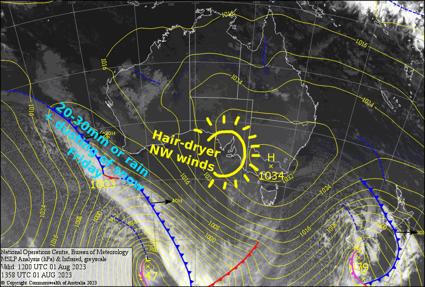
Today will be one we wish we never had, as severe-gale NW winds will likely limit our options for shredding. Throw in 15-30mm of rain during the latter half of the day from a too-little-too-late cold front and it’s not looking pretty.
The cold front should leave a dusting of snow in its wake, maybe a centimetre or three, and skies will eventually clear Saturday as a big happy high approaches. Sunday will be mint too, with a bonus chilly morning that should have the groomers topped up by the snow machines.
Friday 4th
A pretty gnarly day with NW winds reaching severe gale in exposed areas. Skies will be mostly clear this morning, but rain will spread east over Victoria during the afternoon, then NSW in the evening. A period of heavy falls expected, some of which may fall as wet, heavy snow up high, followed by a dusting of snow to low levels at night/overnight as the cold air arrives.
Saturday 5th
Remaining snow showers clear during the morning, then a mostly fine afternoon. However, snow showers will linger over Baw Baw well into the afternoon. Light S-SW breezes.
Sunday 6th
A frosty start should have the snow guns setting us up for a good day, which will be fine and calm, with just some afternoon cloud.
Extended Forecast
Monday & Tuesday will remain mostly clear as the high moves eastwards over the Aussie Alps. N-NW winds will pick up Wednesdaybefore a front give mid-upper slopes a small top up of snow Thursday. Another high will likely keep a lid on things next Friday and Saturday.
That’s all from me today, folks. See you again Monday.


