Grasshopper’s 2024-2025 Japan Snow Season Outlook, November Update – Potential La Niña but Looking Weaker

Mountainwatch | The Grasshopper
One month closer and things are starting to look more like winter in Japan with days shortening, temperatures getting cooler and a few snowfalls last week. If you missed the initial outlook for the Japan snow season it’s available here and worth checking out for the details on what should be a good winter. Things have changed a little, but it’s still looking very positive, so let’s unpack in more detail below.
ENSO Update
You might remember from our last (La Nina heavy) update that there is forecasted to be a La Nina event in the equatorial Pacific over the coming northern hemisphere winter – a good sign for the Japanese snow season. NOAA is putting the number at a 60% chance of a La Nina event developing over the winter which is a slight downgrade from the 71% chance reported last month. Other major international models are still relatively split whether the threshold for an event is reached over the winter with subtle changes in likelihood in individual models, but all suggest a negative anomaly in the central/eastern equatorial Pacific and overall the combined outlook remains very similar with possibly a slight decrease in chance of reaching the threshold. It is interesting to note that the NOAA model appears to be most convinced of a La Nina event forming out of all the majors.
The picture below shows the global SST anomaly from last update (1st of October) against an updated image (8th of November). Looking at the Pacific we can see further development of cooler waters in the central/eastern equatorial region which is promising for the development of a La Nina. In the western Pacific it remains similar, warmer than normal waters but not significantly different from last month.

Other Seasonal Products
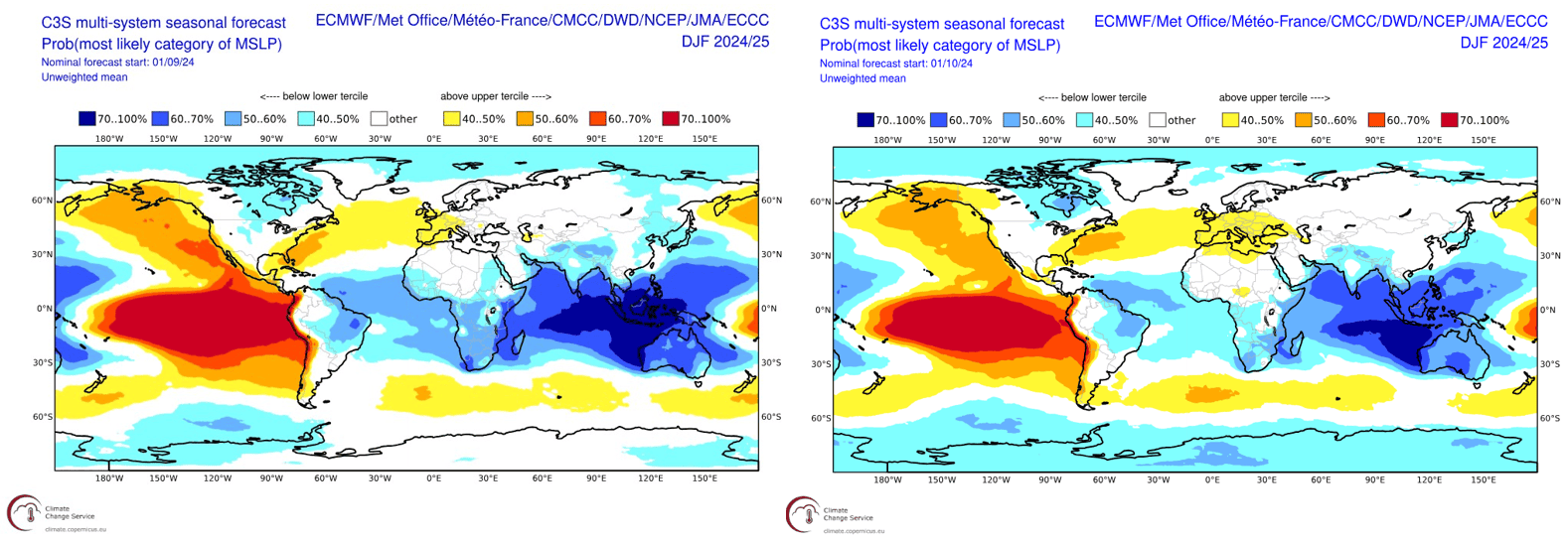
Since the last update there has not been an updated JMA seasonal outlook so instead we look to the following seasonal products, created as a combination of many major global models. Below is another comparison, this time between the forecasted MSLP from last month to this month for the winter period (December – February). Starting with the similar areas circled in the SST picture above we can see slight decreases in the extent of the broad region of high pressure in the eastern Pacific and the low pressure in the western Pacific. This aligns with the slight decrease in expectation that we will reach La Nina thresholds but remain in a neutral slightly negative pattern. Similarly looking to the Japan and specifically to the east over the north Pacific there is a slight reduction in low pressure extent there also. Covered in the last update low pressure in this region can be seen as a way of ENSO communicating with Japan and acts to strengthen the East Asian Winter Monsoon (EAWM), a key local driver of those deep storms coming from the Sea of Japan.

In a slight change of speed If you have had your antennae tuned into the latest meteorological news around the world you might have heard about Mt Fuji breaking a record for the longest time without snow in 130 years. The JMA point to an abnormally hot summer with those high temperatures continuing into the autumn season as the main driver. But do not despair the good news is snow has once again fallen on Mt Fuji breaking the streak and for the reasons talked about above the forecast changes for the winter, hopefully ushering in a change to a bumper snow season for all the Japanese resorts.

Has anything changed…
Overall, the most likely scenario this winter is for a weak La Nina or neutral ENSO phase – not too dissimilar to our last update. Combining this with warmer waters around Japan, average to below average temperatures and potential a strengthened EAWM the snowfall outlooks remain positive. As we all know, average season snowfall totals for Japan still means plenty of powder days. Stay tuned for further updates as we move into the season with not many sleeps to go until the fun begins.


