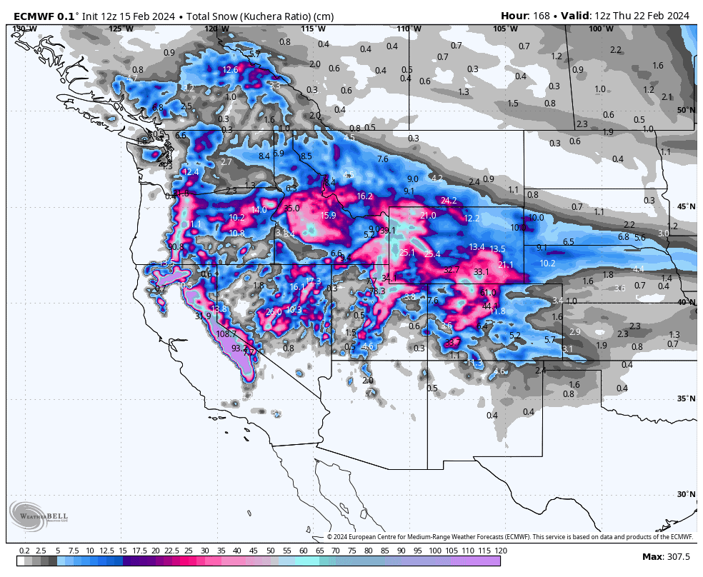
Grasshopper’s Weekly North America Forecast, Thursday Feb 15th – Another Deep Week Lined Up for the Sierras, Southern Cascades and Central Rockies
Mountainwath | The Grasshopper
Written Thursday morning 15th February (Pacific Time)
We’ve got another active seven-day period ahead, favouring resorts in the Sierras, Southern Cascades and the central Rockies. Today and tomorrow, a frontal band will leave a deep band of powder across these very areas, followed by another top-up this weekend from a weaker, mild and moist system, which will see wet stuff mixed in at low elevations near the Coast.
Monday through Wednesday, the Sierras will go super-deep thanks to a strong Pacific storm pushing up into the Coast. Temperatures will trend cooler over this period, banishing any wet stuff to pre-history, with the central-southern Rockies also receiving another decent load.
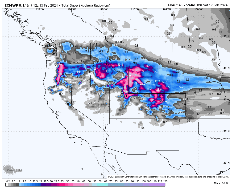
Thursday Feb 15th & Friday Feb 16th
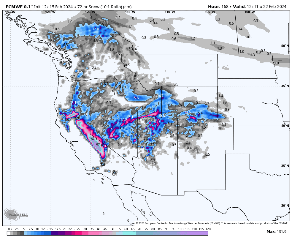
Today and tomorrow will see a band of powder being laid down over central areas, from the southern Cascades to the Rockies south of the Canadian border, down through Utah and Colorado.
This storm system, which has already brought 20-40cm to the northern Cascades and Sierras, is a rather complex system, but is mainly comprised of a near-stationary front marking the boundary between a freezing and drier Arctic airmass to the north, and a warmer, more humid Pacific airmass to the south.
The heaviest falls will be within the Pacific airmass, as that’s where all the moisture is, with 25-50cm+ likely in Oregon, southern Idaho & Montana, Wyoming, and northern Utah & Colorado, adding to the already massive totals these areas have seen in recent days. Although areas just north of this will see lighter falls in the 5-15cm range, it will be high quality stuff.
Snowfalls will eventually clear during Friday, first in the north, then elsewhere late in the day, although they’ll hang on in Colorado into early Saturday, while the cold airmass pushes southwards and warms.
Saturday Feb 17th & Sunday Feb 18th
This weekend, the action continues across central areas as a Pacific front slowly pushes eastwards over the area, bringing a mild and moist southerly flow. The front will first get things started in the Cascades and Sierras early Saturday, before pushing inland to Idaho and Utah Saturday night, then Montana, Wyoming and Colorado Sunday morning as things start to clear in the Sierras and Cascades.
The biggest totals are expected in northern California and southern Oregon, with up to 15-25cm expected around the Tahoe resorts, while 15cm or less is expected elsewhere. However, the snow will be of the denser variety, and rain will be mixed in at low elevations especially in the Cascades and Sierras.
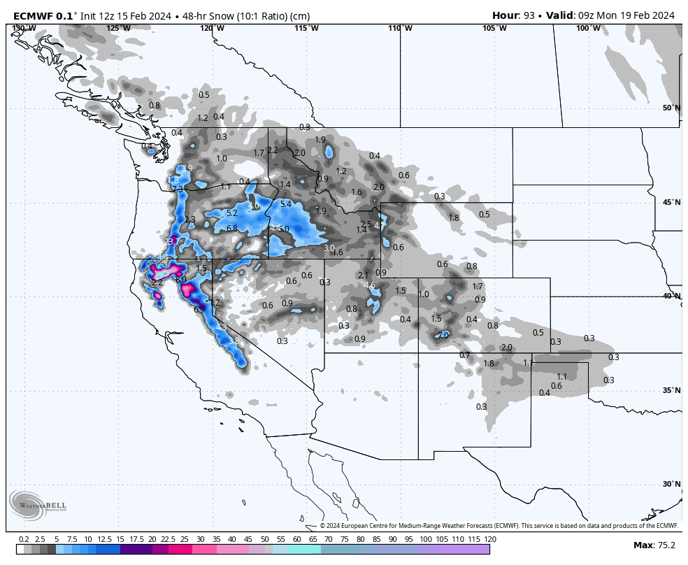
Monday Feb 19th to Wednesday Feb 21st
Come Monday morning the next storm will be well underway in the Sierras and southern Cascades, having arrived in the dead of the night. There’ll be heavy to very-heavy falls, but again this storm will be borne out of a system bringing strong, mild and moist southerlies, so some wet stuff is expected for low elevations, although temperatures will trend cooler during this three-day period as the main low centre pushes into the Pacific Coastline.
During Monday and Tuesday, the storm will spread mostly light falls northwards into the BC Coast Mountains, and inland to the northern and central Rockies as far south as Utah and northern Colorado. Some areas of the central Rockies, such as the Smoky Mountains, Tetons and northern Wasatch will pick up moderate falls, possibly even heavy.
Another surge in the storm from late on Tuesday, this time a little cooler, will see the Sierras receiving another heavy dump of just good ol’ snow lasting through the first half of Wednesday. This extra surge will also benefit the central-southern Rockies during Wednesday, Utah likely taking the cake with moderate-heavy falls, while moderate falls are likely in Wyoming and Colorado.
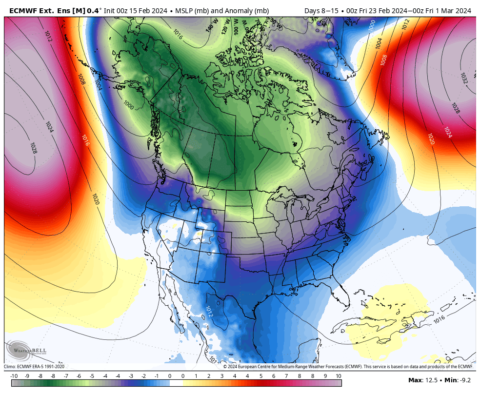
Extended Outlook
After a quiet end to the working week, things look to ramp up again next weekend, starting in the north as storms look to roll down south over the following days, with a trend towards colder temperatures. Overall, it looks to be an unsettled week and big totals could be expected, especially along the Pacific Crest and in the northern & central Rockies.
That’s all from me today. Have a great week, see you next Thursday.
Grasshopper


