Season Outlook 2014 – July Update – Australia
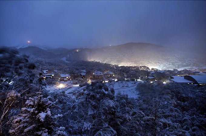
The last few days will be remembered for many seasons to come. A truly epic snowfall. Fingers crossed the “wrong’un” continues to deliver a good bounce. Image:: Thredbo
Australian Seasonal Snow Outlook | The Grasshopper
Brought to you by ESS Boardstores
With the most epic of Julys ahead, this seasonal outlook is a difficult one to make. Last month I was painted optimistic for sticking with my forecast peak snow depth of 172cm at Spencers Creek. This month, if I stick with that I’m going to be called a Grinch. Let’s check this season’s heartbeat and let the cards fall where they may
Righto. If you’re coming into these seasonal outlooks late then you’ve got some homework to do, and the best place would be my first seasonal outlook, issued back in early April.
The dog ate it
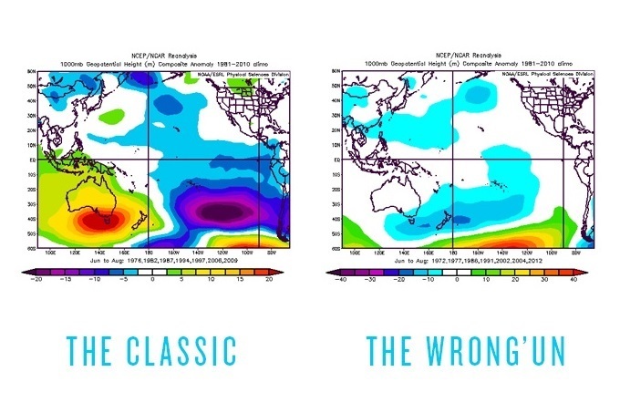
Long story short, I’ve been a voice in the wilderness warning that El Ninos come in different flavours. One of those groups is characterised by higher surface pressures over most of Australasia that kills rain-bearing systems and really puts the kybosh on snowfall. This is the more classic El Nino pattern.
The other group of El Ninos, which we nicknamed “Wrong ’uns” (because they spin the wrong way), has on average resulted in lower pressures south of Victoria which has resulted in increased frontal activity and very decent snowfall, thank you very much.
But a month ago we still had very little idea of what season 2014 held. Would it be a classic like 1982 or a wrong’un like 1991?
El Nino has two sides to it. Image::Snowy Hydro
Quoteable quotes
Here are some interesting quotes from when I left off last month:
- “Is it time to panic and press the eject button? Nah, I don’t think so. But it does appear that June will be a bit grim until right at the end.”
- “I wouldn’t be hopeful of anything until after 18 June”
- “I’m sticking with my call from last month, for a peak snow depth of 172cm at Spencer’s Creek, with the first big 50cm+ storm arriving from late June to early July, snow depths hitting the one metre mark in early August
- “If we get to my next outlook in a month’s time and we haven’t seen any action then I’ll be forced to start selling the season short.”
That last sentence makes me laugh. I wasn’t ready to panic a month ago, but I sure as sugar didn’t think we’d be sitting on over a metre base. There’s certainly no need to sell the season short any more, thanks to a fortnight of conditions that can only be described as very “wrong’un” like.
In the nick of time
Yes, that’s right, it’s fair to say that for the last half of June, we’ve been solidly in a “wrong’un” El Nino pattern, with those low pressures dominating south of Victoria and bringing all of that beautiful cold air up over the Alps.
This doesn’t mean that things are necessarily going to continue in a wrong’un El Nino pattern for the whole winter. There’s nothing to say the switch won’t flip at some stage. In fact, the models are suggesting that this wrong’un flavour is going to last through July, but through August and more so September we can expect the lows to become less of a feature, and the highs to throw their weight around in the Bight a bit more.
This isn’t all bad news. Highs in the Bight mean southerlies, and southerlies mean cold air, so even if it wasn’t snowing heaps, we should get just enough feeding in to keep things ticking over.
By the numbers
The other thing to note is that, historically, June is the time when the Wrong’uns really show off. Six of the last seven wrong’uns have had bases over 80cm by the end of June, whereas only one out of seven Classics managed the same thing. But there’s not as much difference between Wrong’uns and Classics from July onwards. The Wrong’uns tend to put on another metre on average from this point of the season. The Classics about another 80cm.
I’m inclined to split the difference between these two averages and forecast another 90cm of base building up between now and late August or early September.
But the BIG question is on top of what? You see we won’t get an update of the base at Spencers Creek until Thursday. When we get one, it’s going to be affected not only by the extra snow we received on the weekend, but also by how much last week’s snow is packing down. And I’d expect things to continue to compact quite a lot over the next couple of weeks. So while we might get a reading on Thursday of something around 160cm, I think given a few weeks we’ll see that existing base pack down by 30 to 40cm.
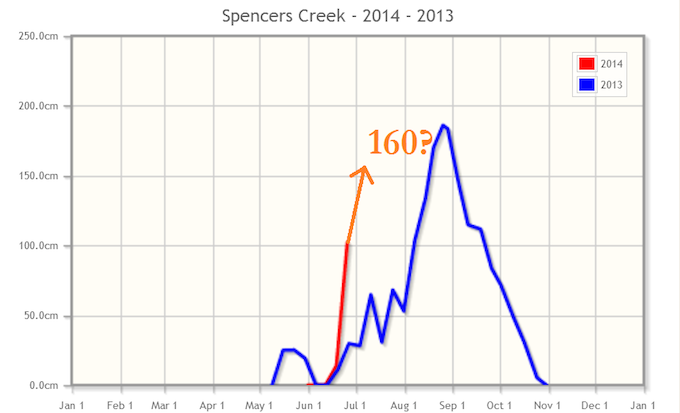
This week’s reading from Snowy Hydro will show a mind-boggling increase over 3 weeks. But who’s complaining? Image::Snowy Hydro
Put your money down
If we assume a “real” base of 130cm, and whack 90cm on top of that, then we end up expecting a peak snow depth this winter of 220cm, which is within spitting distance of five previous wrong’un El Ninos. I’m happy to run with that as my new forecast for the peak snow depth at Spencers this season.
Remember there are two significant sources of error here – how much snow base we’ve already got AND how much extra we’re going to get. If both those errors push in the same direction my forecast could be way out. But then again they might cancel each other. Either way, I hope you’re happy with that season pass you bought, ‘cause there’s a lot of riding to be had between now and October.
That’s all from the Grasshopper. We’ll update this outlook in early August. If you’ve got a different theory on what’s going to happen this winter, or just want to provide feedback, then please join in the discussion below, or hit me up at grasshoppermw@gmail.com or facebook.
Don’t forget to subscribe to my weekly Weekend Forecast email:

Perisher forecasts,
snow reports and
live snow cams.
Falls Creek forecasts,
snow reports and
live snow cams.
Mount Buller forecasts,
snow reports and
live snow cams.
Charlotte Pass forecasts,
snow reports and
live snow cams.
Thredbo forecasts,
snow reports and
live snow cams.
Mount Baw Baw forecasts,
snow reports and
live snow cams.


