SEASONAL OUTLOOK 2013 – Australia – June Update
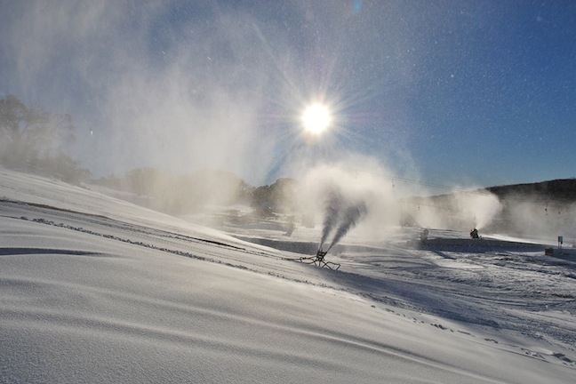
Perisher have been working hard to make snow whenever possible, unfortunately rain this week may damage any chance of an early opening Image:: Perisher
Australian Seasonal Snow Outlook – June update | The Grasshopper
Brought to you by ESS Boardstores
Let’s go. Daily forecasts start today and I’m hyped to once again have the privilege of bringing you weather updates every morning throughout winter, and looking forward to following the fortunes of Australia’s snow lovers over the next few months.
To kick things off in style we’re also releasing this updated seasonal snow outlook to look specifically at what we can expect over the next few weeks as we try to get this season off the ground. But first let’s set the scene with a quick update on the current climate situation.
A couple of weeks ago in our mid-May update we called your attention to a growing signal for a negative Indian Ocean Dipole (IOD) event and outlined how this increases (but certainly doesn’t guarantee) the odds of an above-average snowfall this winter. Nothing has really changed since that outlook, so have a read of it for the full rundown. The chart below shows those warmer than normal sea surface temperatures slowly developing north-west of Australia.
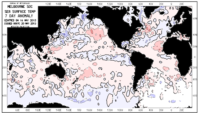
Source:: Bureau of Meteorology
Better late than never
Other media outlets have now picked up on this IOD event following an official nod from the Bureau. I reckon you’re going to hear a bunch more about a wet winter over the next month or two. When you see these reports, remember that it’s not just the chance of a wet winter that we should get excited about – it’s the fact that average to above average precipitation should hopefully coincide with average to below average temperatures, which would mean that a good proportion of the precipitation that did fall would be snow.
Let me prove the point: Last season was wicked, particularly through August. But precipitation was close to normal for Perisher and Thredbo during this period (admittedly a bit above average for Falls and Hotham). What mattered more was that it was more than cold enough when it mattered, resulting in snow, not rain.
We’ll bring you the latest on this IOD event around 20 June, when there should be something fresh to say. Let’s check out what we can expect between now and then:
The month ahead
This week will start fine under a high and tend towards rain later, as per today’s daily forecast.
The first week of June is setting itself up to follow a similar pattern, with a weak high early in the week leading to clear, dry conditions that may allow some cooler nights and a little snow-making. There’s good potential for this high to be followed by a cold front leading up to opening weekend and I think this feature has an even chance of dropping a little fresh above 1800 metres. Of course I’ll provide updates on this as we get closer, so stay tuned.
Post opening weekend there’s not a lot I can point towards specifically. Following that front around opening weekend the odds are that another high pressure system will push in from the west. In the second half of June I would expect we’ll start to see some of the influence of the warmer waters to the north-west of Australia. So, any cold fronts that do come through should undercut a north-westerly flow with a little extra juice than normal. Provided we can get a normal level of westerly wind activity the snow bases in Victoria and New South Wales should start to build nicely from this point.
By the numbers
I’m going to maintain my forecast of 198cm for the peak snow depth at Spencers Creek this winter, breaking 1 metre around mid-July and topping out early-to-mid September. There’s about a 1 in 3 chance we could sail past 230cm, but also a 1 in 5 chance we could fail to break 150cm. We simply have to talk in probabilities here – it’s the only responsible way to deal with the atmosphere more than a week into the future.
That’s my take. If you want to let us know what you reckon please join in the Facebook discussion below or hit me up at grasshoppermw@gmail.com.
Perisher forecasts,
snow reports and
live snow cams.
Falls Creek forecasts,
snow reports and
live snow cams.
Mount Buller forecasts,
snow reports and
live snow cams.
Charlotte Pass forecasts,
snow reports and
live snow cams.
Thredbo forecasts,
snow reports and
live snow cams.
Mount Baw Baw forecasts,
snow reports and
live snow cams.


