Alpine Meteorology – Where the Snowfalls Came From

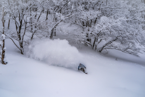
Jordon Haughton at Perisher making the most of this blessing from the gods. Image:: Harro
Words | Aaron Cook – Alpine Meteorologist
Everyone who loves the mountains has been blown away by the storm that came through this week. After four previous large snow events during August, the latest dump has pushed the monthly total to record levels at some resorts.
The cause of this latest gift from the gods was a massive area of low pressure extending up from the southern ocean, so let’s take a look at how it developed.
Tuesday 24 August 2010

Here’s the chart from Tuesday lunchtime, with a garden variety cold front in the Bight making landfall. You can see the cloud band running along ahead of this front in the satellite image. We thought we would get 10 to 15cm on Tuesday, then 20cm on Wednesday and 10 to 15 on Thursday. We were all pretty happy with the half metre forecast over three days.
Wednesday 25 August

Tuesday delivered a good blast of snow, with 20cm at Falls Creek. That cold front was now lying in the western Tasman Sea. But the best was still to come. Our forecast models now said 30cm Wednesday and another 30cm Thursday. Time to get excited.
Check out the trough in the centre of the image above. Nice tight isobars bearing down on the resorts. What you can’t see is that this trough extends right up through the atmosphere, driving plenty of upward motion that sucked moisture up, and cooled it down, so it could then fall as rain and snow.
You can see there’s an awful lot of cloud related to that trough in the satellite image. Notice how the cloud is banking up on the western side of the alps at this point, so while it was already going for it over VIC resorts, it hadn’t quite started over NSW yet. My guess is that this is why VIC resorts did so much better.
Low freezing levels meant it snowed steadily over the VIC resorts during the afternoon, then it absolutely dumped everywhere when that trough came over during the evening.
Thursday 26 August

So I wake up Thursday, make myself a milo, and log-on to see that Steve Lee is bragging about 54cm at Falls Creek. But there was still more to come, and another 20 to 30cm was dropped across the resorts Thursday in strong Westerly winds. At the time of writing we’re expecting another 10cm to fall Friday.
There was nothing super-natural about this weather system. It was just a monster area of low pressure that had its wicked way with us. But don’t you wish that we could schedule a low like this around opening weekend each winter!?!
August is drawing to a close and it’s going to wrap up with fine weather, but check out the Mountainwatch snow forecast for the 1st and 2nd of September. Best September ever anyone?


