Grasshopper’s 2026 Australian Snow Season Outlook – May Update
Mountainwatch | The Grasshopper
Here we are, late May, only 10 days until the “official” start of the Australian snow season and it’s long left until we can expect some of the first snowfalls to grace the Aussie Alps for this winter.
Some early season rumblings are happening in the atmosphere with a few systems set to deliver some wild weather to areas of southern Australia over the next couple of weeks. While there will be some wet weather in the coming days there are two systems due later in the week that will have more of an influence on the start to the season.
First up, a system is expected to roll through the Aussie Alps over the end of the coming weekend. It will only drop small amounts of snow but accompanying colder temperatures should allow resorts to get a foothold with snowmaking operations.

The second system is a low that will deepen to the southwest of the country late in the weekend and at this stage I expect it to reach the mountains from around Tuesday. Some models have this low quite deep, bringing some wild weather with strong winds to southern regions of the country and a better chance of snow across the Alps during next week.
An important note with both systems is that the temperatures may be marginal for snowfall below higher elevations, a consequence of being in the early season.
The best-case scenario for the upcoming week is that we see a small amount of natural snow but accompanied by cool temperatures to allow for snowmaking operations around the grounds, before some more noticeable natural accumulations next week.
I’ll be back on Monday with my first detailed short-term forecast for the season and things will be clearer on what we can expect for the opening weekend.

Quick Seasonal Recap
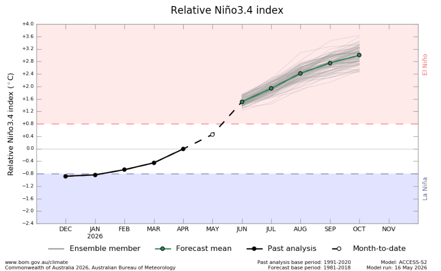
The news wasn’t great in our initial season outlook last month as indications were that a strong El Niño is developing which has the potential to throw a spanner in our dreams of a deep Australian winter.
This is still the case and as we can see below there is a good consensus we are heading towards an El Niño event this year, with the potential for a strong to very strong event to manifest. As for numbers NOAA has an 82% chance of an El Niño event to emerge in May-July and a 96% chance of El Niño conditions in December-February.
Comparing Apples to Apples
Instead of going into more of the same graphs I thought it’d be good have a look back to 2015 when we were in similar pre-season situation.
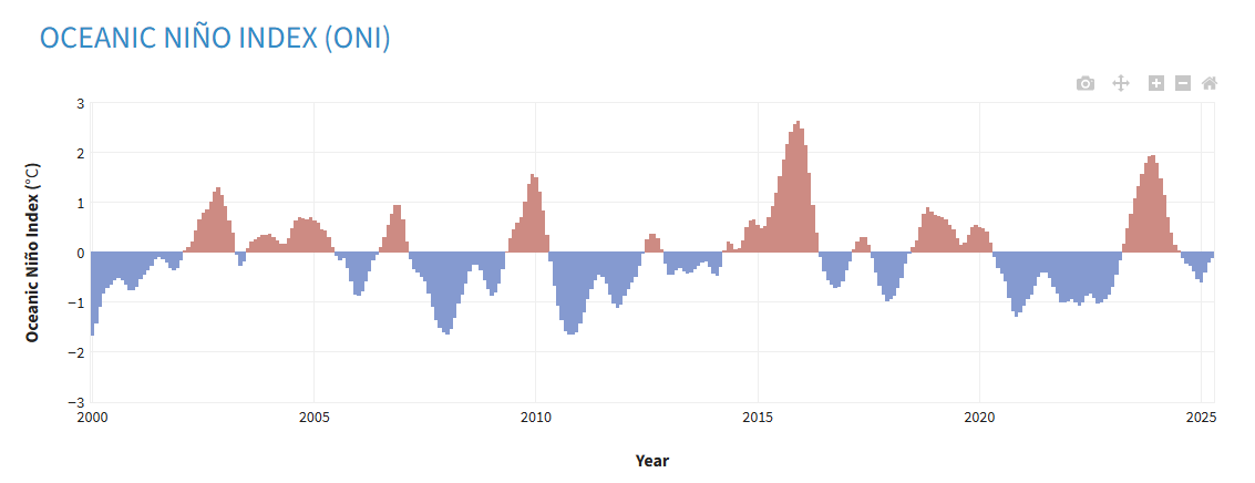
Heading into the winter of 2015 we were coming off an ‘almost El Niño’ instead of last season’s neutral year. Below is a plot of the Oceanic Nino Index since 2000 (ONI, think of it as analogous to the Nino3.4 index) and 2015 stands out as the strongest El Niño event recorded.
Also heading into that winter season there was some indication of a negative IOD, but it turned out to be a positive IOD event during the season.
So, what happened in 2015?
2015 saw a strong El Niño event develop alongside a positive IOD event. The winter itself was categorised by a traditional (less than ideal) ENSO pattern to start with not much excitement on the slopes. But a resurgence in July/August saw a few strong storms contribute to the bulk of the snowpack with, reaching a peak depth of 150cm at Spencer’s Creek.
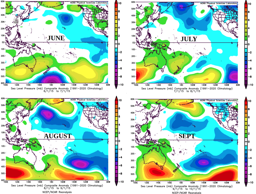
Looking at a few plots of the pressure pattern anomaly through the season we can see this in action below. A traditional strong high-pressure anomaly over southern Australia weakened through July with a few strong low-pressure systems driven up from the southwest, before the high-pressure anomaly strengthened again.

So, a strong El Niño event is not certain chaos for the snow season but there is some luck required. If the high-pressure anomaly over the south of the country remains too strong in the absence of any low-pressure systems brave enough to challenge it then it can result in long dry spells with minimal storms to speak of, but this is not a total guarantee.
While that season had a slow start, the clear nights and cold temps allowed the snowmakers keep things moving earl and there were some very good days during peak season. Check out the 2015 Season Wrap, “A Season of Highs and Lows”.
Back to the future
So, what can we learn from the trip down memory lane above? Well, unfortunately no two ENSO events, or snow seasons are the same, but they can give us some clues. Right now, we are looking at a possible strong to very strong El Nino event developing throughout this year. It also looks as though this will be a traditional El Niño event, potentially combining with a positive IOD event to put a damper on our grand winter plans. But as we seen above even in the face of a strong El Niño event a month with a couple of strong storms can dramatically change the outlook of the season.
This is not to say expect a carbon copy of the 2015 season but more to show that the moral of the story is we are going to need to stay tuned to see how this season develops with hopes that we can see glimmers of hope shine through like they have in the past.
I’ll be back next month to revisit our seasonal plan just as things are hopefully getting going. Until then stay across conditions with my short term detailed forecasts every Monday, Wednesday and Friday, starting on June 1st.