Australian Weekend Forecast, July 14th – Gale NW Winds To End With 1-5cm For Victoria Late Saturday
Mountainwatch | The Grasshopper
Written early Friday 14thJuly, valid Sunday 16thJuly
No one will blame you if start to feel irritable these next couple of days – you won’t be the only one! It won’t just be the school holiday lift queues that’ll be affecting your mood, it’ll be these dastardly northwesterlies.
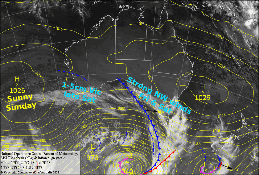
The NW winds will continue be up at gale force today and Saturday as a front approaches from the west. The front will weaken significantly by the time it reaches us late Saturday, coughing up only 1-5cm of snow for Victoria, and barely even managing to wring out a single snowflake for NSW. However, high pressure will bring lighter winds and sunny skies for your Sunday session.
Friday 14th
Gnarly gale force NW winds today. There’ll be a bit of high cloud overhead, and the winds will also have some lower level cloud blowing onto Victorian resorts, particularly during the morning.
Saturday 15th
Another day of NW winds, which will be up at gale force again, but it’ll start to ease a little from afternoon. Skies will be partially sunny, partially cloudy – both the high and low level stuff.
A weakening front passing over during the evening/night should see between 1-5cm falling over Victoria, but nothing measurable for NSW.
Sunday 16th
A fine, sunny day. S-SW breezes gradually turning to the W-NW.
Extended Forecast
NW winds will again strengthen before a cold front brushes the Aussie Alps during Tuesday. Only a skiff of snow is expected, but the cold temps should get the snow guns pumping. Wednesday will be nice and sunny under high pressure.
The back half of next week looks promising; We could see a series of fronts bringing light snowfall across Thursday and next Friday, followed by a more active system and heavier snowfall next weekend.
That’s all from me today, folks. See you again Monday.


