Australian Forecast, June 12th – Unsettled Westerlies to Deliver 5-15cm Tue & Wed
Mountainwatch | The Grasshopper
Valid Monday 12thJune to Thursday 15th June
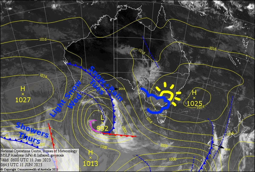
Well, it’s been nice social opening weekend with a lot of sore heads, little skiing and even less snow on offer. Over the next several days an unsettled W-NW flow will descend upon us as a broad low pressure system twists and turns far to the southwest in the Southern Ocean.
Monday will be the nicest in terms of weather, but Wednesday is the pick of the bunch after a cold front hits the day before with snowfall possibly lowering to 1300m. With further light snowfall during Wednesday, all up we’re looking at 5-15cm, with 20cm on the highest terrain. It’s not the season starter storm we’re all waiting for, but it may be enough to make it the first proper skiable day of the season.
Monday 12th
A partially cloudy day, but the sun will dominate during the afternoon. N-NW breeze.
Tuesday 13th
A cloudy, clagged in day, with just patchy drizzle at first. Periods of rain kicking in from late morning with snow levels gradually lowering from 1900m down to 1500-1600m by the end of the day. A stiff N-NW wind blowing.
Wednesday 14th
Light snowfalls will continue throughout the day, down to 1300m at first, then gradually lifting to 1500m.
Thursday 15th
More cloudy, clagged in weather, with drizzly, showery stuff building over on the Vic side during the morning as snow levels lift to about 1900m. The showers will spill over onto the NSW side during the afternoon. Brisk W-NW winds.
Extended Forecast
Unfortunately, there’s no big dump on the horizon yet guys! Friday through Sunday will be a mix of cloud, patchy drizzle, and sunshine before a weak cold front looks to bring just a dusting next Monday into Tuesday. This cold front could bring significantly cold air, which will give the snow guns a good chance to fire up. The following couple of days will be worth keeping an eye on for another potential snowfall event.
That’s all from me today, folks. See you again on Wednesday!


