Grasshopper’s Weekly North America Forecast, Feb 1st – Dump of The Season for The Sierras as Duo of Storms Produce Massive Totals Across the South & Central Ranges
Mountainwatch | The Grasshopper
Written Thursday morning 1st February (Pacific Time)
Well it’s been a tough week, especially in the Pacific NW which copped more than its fair share of rain and warm temps. Although little snow will fall there over the next 7-days, temps are on the downward trend and some remedial work will be possible.
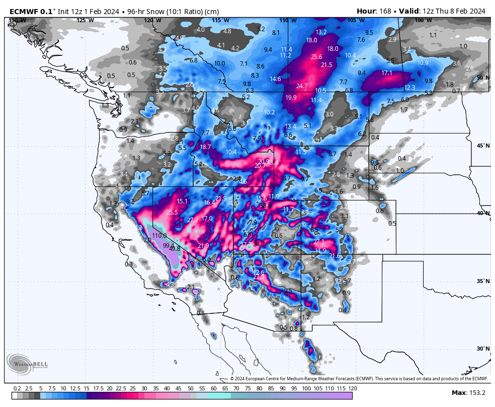
All the action will take place further south, however, with two massive storms slamming into the Sierras before spreading inland and northwards throughout the Rockies. I’ve conveniently divided the forecast into two to cater for this duo of storms, which will produce insane numbers in the Sierras, as well as the central and southern Rockies. The second of such storms, will likely produce the biggest totals we’ve seen this season!
The northern Rockies too will receive a tidy helping, especially southern parts, with temperatures also climbing down to much healthier levels.
Thursday Feb 1st to Saturday Feb 3rd
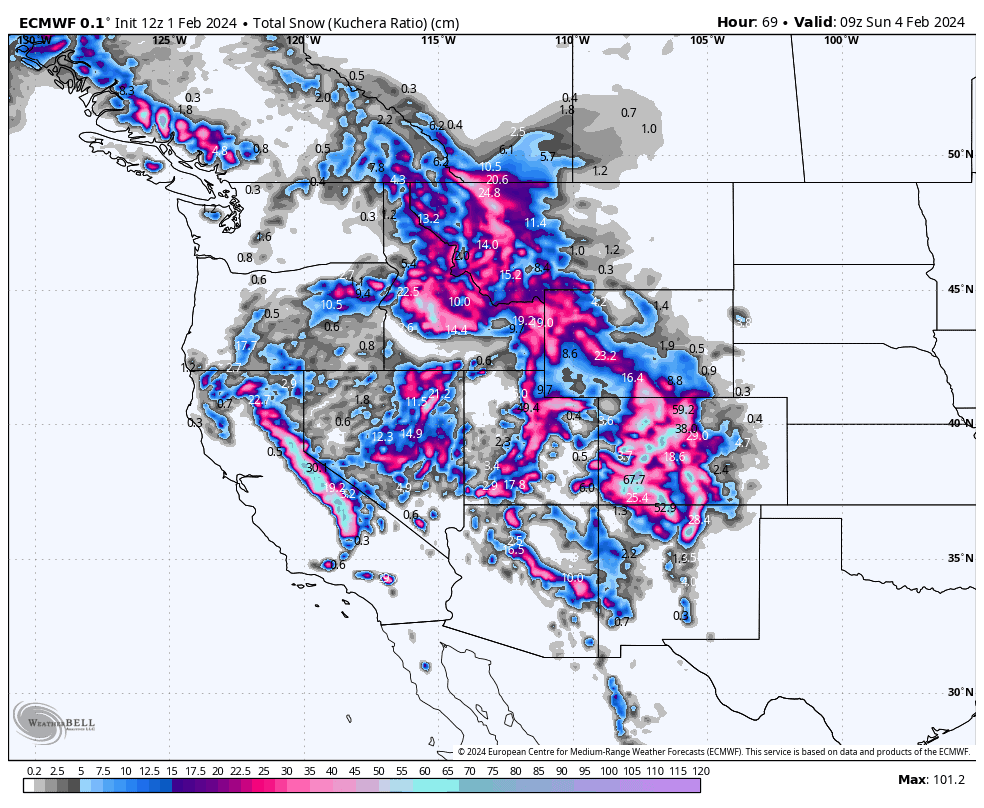
The mothership of low pressure, normally sitting near the mouth of the Gulf of Alaska, has finally made a move towards the west coast and is sitting just offshore B.C. and Washington State. Yesterday, the low sent in a strong front to hammer the Pacific Crest, the Sierras taking the full brunt where Mammoth reported 30-35cm of new snow early this morning.
Heavy snowfall has continued in the Sierras this morning. The good news is light-moderate falls will continue the rest of today through Friday before clearing during Saturday, all the while temperatures will continue on a downward trend.
The downward trend in temperatures will be felt elsewhere too, as the front makes its way into the Rockies from later today where snow will fall in some shape or form along its entire length all the way through Friday and Saturday.
In general terms, a tepid southerly flow with elevated snow levels will switch to a colder N-NW flow Saturday. So, as a result, we’ll see the heaviest falls in the central-southern Rockies from later today through Friday, shift up to the northern and northern-central Rockies during Saturday.
After a very heavy, warm and wet lead-up, the Cascades and B.C. Coast Mountains will also be thankful to see snow levels creep down as periods of light-moderate snowfall continue through the rest of today and Friday. However, the moisture dries up for Saturday as the colder northerlies arrive, so we won’t see snow reach base levels, which resorts there are desperate for.
Sunday Feb 4th to Wednesday Feb 7th
Sunday, light-moderate snow still falling in the Rockies will gradually contract north of the Canadian border by the end of the day. At the same time, the mothership, now in her weakened state, links up with a younger, bolder low-pressure system, originating from warmer climes in the southern North Pacific.
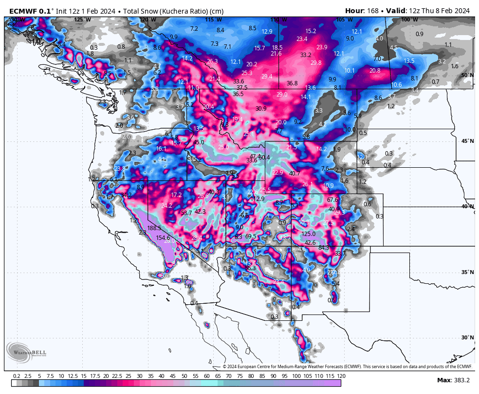
This new storm system will actually start to arrive in the Sierras Saturday night, kicking off very heavy snowfall there Sunday through much of Monday. Snowfall accumulations will be huge, it’s hard to put numbers to it, but current models have them ranging from 75-150cm around the Tahoe region, to upwards of 150-250cm+ south of there – it’s looking like THE BIGGEST STORM OF THE SEASON!!! Temperatures aren’t super cold, but such heavy precip will see snow falling to base levels. Lighter snow showers will persist through Tuesday and Wednesday with colder temps too.
As usual, this storm will work its way inland too, with a S-SW flow producing heavy snowfall in the central Rockies Monday, then the southern and south-central Rockies Tuesday and Wednesday.
The northern Rockies will also see periods of lighter snowfall throughout this time, and the Cascades and B.C. Coast Mountain just flurries at times. However, temps will remain nice and cold and should allow the snow guns to rebuild the base at the lower altitudes.
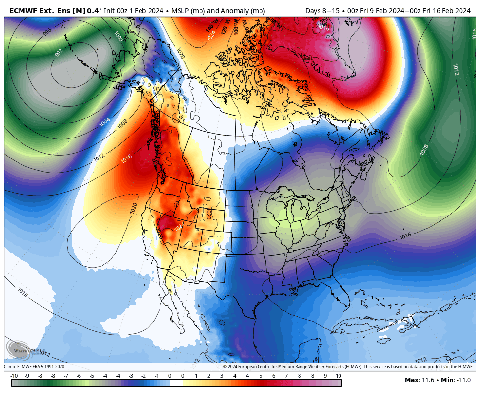
Extended Outlook
The pattern looks to remain active, with storms shifting their focus from the southern half to the northern half next weekend briefly before high pressure settles things down through at least the early parts of the week starting Monday 12th Feb. Things look to become unsettled again towards the end of that week.
That’s all from me today. Have a great week, see you next Thursday.
Grasshopper


