Grasshopper’s Weekly North American Forecast, December 16th – All Quiet Down South, Light n’ Fluffy Snow Up North Before the Heavy Falls Kick In Tuesday
Mountainwatch | The Grasshopper
Valid Thursday 15thDecember to Thursday 22ndDecember (Pacific Standard Time)
Welcome ya’ll to the first Weekly North American Forecast of the 2022-2023 season, where I’ll be providing you with all the main weather highlights and snowlights of the coming week.
In case you haven’t been tuned in to what’s been happening up here, North American resorts have had an amazing start to the season. Snow packs are deeper than average for this time of year, especially in the Sierra Nevada mountain range where over twice as much snow has fallen compared to average.
Last weekend alone saw roughly 0.5-1.5m dumped on Californian resorts after a lazy low ambled its way inland from the Pacific, which then went on to dump similar amounts on Utah and Colorado.
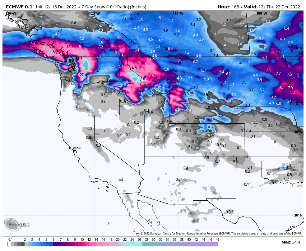
This week will remain relatively quiet as high pressure dominates the south. Light n’ fluffy snow will fall over the north this weekend and Monday, before a tight and compact low brings moderate-heavy snowfall to those same areas during Tuesday and Wednesday, the results of which are highlighted in the 7-day snowfall chart below.
Thursday Dec 15th & Friday Dec 16th
With the Lazy low off doing its thang over the Midwestern States, high pressure settles down over the west bringing clearing skies, with just a couple-few centimetres of light snow showers yet to fall over the U.S. Rockies today (Thursday).
Saturday Dec 17th & Sunday Dec 18th
With high pressure fully ensconced down south over the weekend, nothing much will happen over the Sierras and central-southern Rockies, apart from mostly sunny skies and happy smiles.
Further north on Saturday, light n’ fluffy snow will migrate southwards over Canadian resorts, down into northern half of Idaho and Montana, as well as the Pacific NW. This is all due to the Artic high up north building in pressure, pushing an absolutely frigid airmass southwards, while a wee low circulates over the Pacific NW, brrrr!!!
By the end of Sunday, snowfall should mostly have cleared north of the Canadian border and begun easing elsewhere, leaving behind roughly 10-20cm of top quality powder.
Monday Dec 19th
From late Monday a weak disturbance bringing moisture in from the Pacific will send more light scattered snow showers over the Pacific NW, northern Rockies of the U.S. as well as the Sierras briefly Monday night.
Tuesday Dec 20th & Wednesday Dec 21st
Tuesday, a tight and compact low will hit the northwest, spreading moderate to heavy snowfall inland over Canadian resorts, the Pacific NW, and the northern U.S. Rockies of Idaho, Montana and Wyoming.
As the low scoots off to the southeast during Wednesday, snowfall will eventually clear north of the Canadian border, but continue over the Pacific NW and northern U.S. Rockies, while likely spreading into the north of Utah and Colorado.
Elsewhere further south will stay dry and mostly sunny under high pressure.
Next Thursday Dec 22nd & Beyond
From next Thursday onwards, an active storm cycle looks to favour the north, turning the tables on this past week. However, temperatures could get awfully warm, bringing rain or wet, heavy snow to lower-mid slopes.
Well, that’s all from me this week guys, get amongst and see you next Thursday.


