New Zealand Weekly Forecast, July 11 – A Snowy Tuesday and a Wild Week Ahead
Mountainwatch | The Grasshopper
Valid July 12- July 17th
After a couple of mellow partly cloudy days today and yesterday, a big snowy change is due on Tuesday ahead if another week dominated by low pressure systems. More good snow for the south but a mixed bag for Ruapehu.
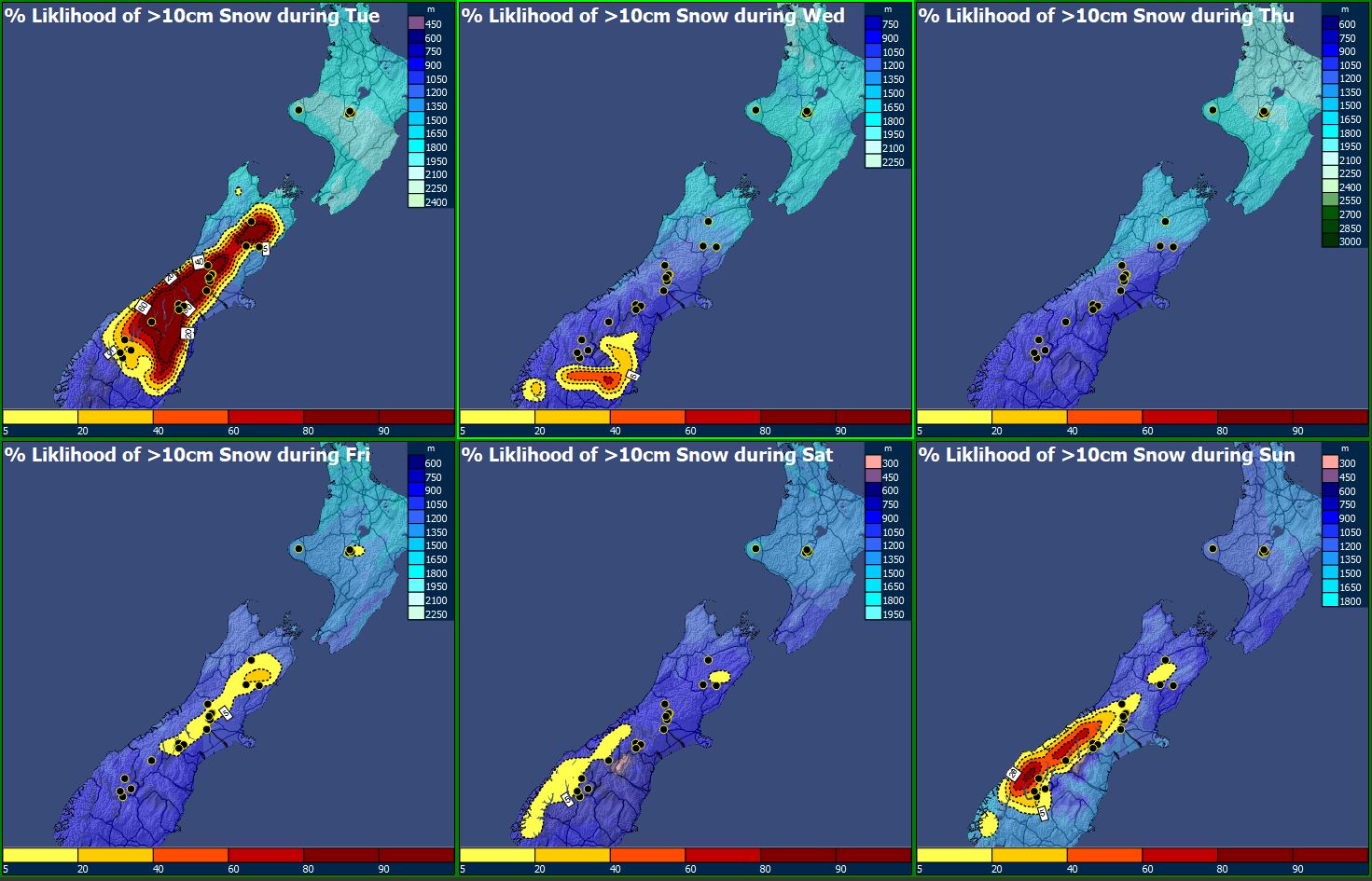
Tuesday 12th July
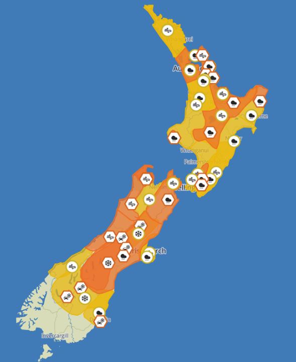
A deep low spreads its influence over the whole country today as it moves only slowly across central New Zealand. Aotearoa is absolutely chock full of weather watches and warnings (see image), so make sure you stay on top of those https://www.metservice.com/warnings/home. The Canterbury fields should pick up an epic amount of snow from this – more than half a metre for most, with the possibility of a metre showing up in some favoured spots. The Queenstown and Wanakafields won’t do badly either, maybe picking up around 5-20 cm.
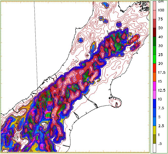
Ruapehu is going to be caught in the warm sector of this low – that means heaps of rain, which for most of the day will probably only fall as snow for the upper mountain. All is not lost, as the low moves away later in the day colder air feeds in with a showery westerly flow, bringing snow down to the lower mountain as well. Whakapapa will probably do best out of this. Totals around 20-30 cm for the upper mountain, and around 5-10 cm for the lower mountain – possibly a bit less around Turoa.
Wednesday 13th July and Thursday 14th July
After reading all that, the Grasshopper faithful will be wondering when they can get among it? The lingering low spreads a trough across the middle of the South Island. To the north of this: westerly winds put a limit on the fun times. To the south of the trough, clagged skies and a few snow flurries.
The sweet spot in between is probably from around Cardrona to Mt Hutt. Don’t think vintage saccharine though – more like if you got a handful of organic stevia leaves when you were hoping for a pineapple lump: skies should be about as clear as you could reasonably hope, and there shouldn’t be much (if any) wind, though it does get a bit more marginal around Mt Hutt. This is a messy situation and it pretty much continues into Thursday as well.
Ruapehu is stuck in the westerly flow on Wednesday. This day looks unpleasantly windy, as well as clagged in. Snow showers should continue to at least maintain the base. Thursday at least should see the wind easing and possibly a few breaks, but it’s only a slow and brief improvement.
Friday 15th July and Saturday 16th July
Another (yes, really) low comes barrelling down from the north. This’ll be on a smaller scale than Tuesday’s beast and really only affects the North Island. Ruapehu could get a better dumping from this event, but as models jump around a little it’s hard to say how much. Saturday is a little ropey – there’s tentative signs the low moves away but this is likely to be a complicated clearance and could bring a messy day, though should at least have lighter winds.
SW or SW conditions for the South Island on Friday – neither of which is expected to bringeth the bluebirds – expect mostly cloudy skies and further flurries. Saturday, meanwhile, could see the clearest conditions of the whole week as a narrow ridge of high pressure moves in. You may want to set your sights on this day as it could be the diamond in the rough.
Sunday 17th July
The high is barely holding on for the South Island on Sunday. If you’re up with the larks, you could get some important work done before the NW really starts picking up. By the end of the day, expect gales to wrap up the meeting. Further snow is possible later.
Sunday could well be a vintage day for the North Island – at last – as the high moves on. When tracking a brief high like this, just watch out that timings could well change nearer to the time.
Extended Outlook
The high should have moved away on Monday, and a NW flow squeezed between it and the next front covers the country. Expect gales and rain ahead of and with this front, which sees us through to the end of Tuesday. After that, it’s the typical “pick your adventure” at this sort of time range and everything will depend on whether the front stalls, or moves through quickly, or whether it gets caught up with another Tasman low again.


