SEASON OUTLOOK – Aussie Update, We’re in for a Cold One
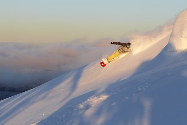
Jyothi Jaffray getting some dawn rays at Hotham on 23 June. It’s been an excellent beginning to the season. Image:: Mark Tsukasov
Season Outlook | The Grasshopper
Brought to you by ESS Boardstores
The dump of the season so far has just piled half a metre of snow across the Aussie Alps, upping excitement levels throughout the Australian Ski Industry. Now is as good a time as any to update our seasonal outlook and have a think about what we can expect through July and August.
In the April edition of the outlook I was feeling pretty neutral about the prospects for the year, picking a peak snow depth of 170cm at Spencer’s Creek in the Snowy Mountains, just shy of their long term median of 176cm.
Then last month I upped my forecast of maximum snow depth at Spencer’s to 201cm. This was because of a signal for some increased low pressure activity about and south of the Aussie Alps, plus signs that the year was starting to look similar to 2004.
So what’s changed? Well I think we’ve already seen the increased low pressure activity we were expecting and that will now trend back towards normal. The latest seasonal data I’m seeing suggests an El Nino will continue to slowly form in the Pacific. This could be expected to suppress rainfall and low pressure activity over northern Australia and Indonesia, and also help to maintain the sub-tropical ridge of high pressure that runs west to east across central Australia during winter.
At the same time, there’s also a signal in climate models that high pressure systems will tend to form and persist in the oceans south-west of Australia, with westerly and south westerly winds feeding cooler air into the Australian region.
Taken as a whole, that’s likely to mean less precipitation over the Aussie Alps because of the higher pressures, but also colder conditions during rain events, because the air originates from a bit further south.
The Bureau map below is a good example of how I think we will pick up a lot of our snow until the end of August. The cold front you can see that is just about to pass over south-east Australia doesn’t have much in it, maybe 5 to 10mm/cm. But that high will have been feeding in cooler westerlies ahead of the front so when it does arrive, the balance will be tipped towards snow rather than rain.
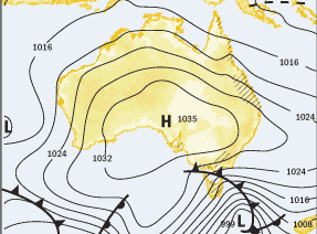
These short, sharp top-ups are likely to be followed by extended periods of dry weather as the highs themselves drift over the resorts. That will bring nice dry weather for skiing and good overnight cooling for snowmaking.
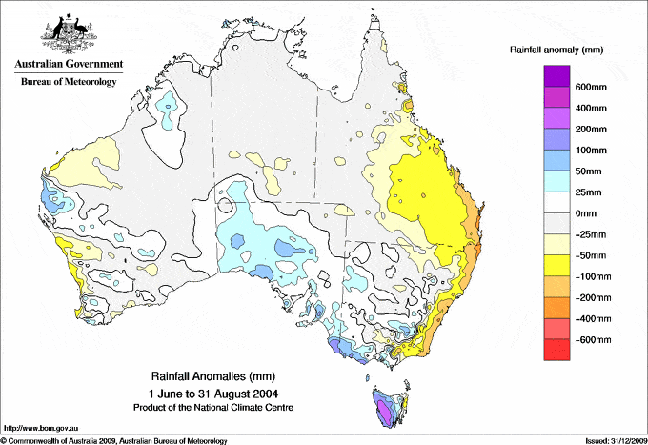
Here is a great example of why less rainfall is not always a bad thing. You can see in the image below that from June to August 2004, another year that saw a weak El Nino form during late winter, the Aussie Alps saw 50 to 100m less precipitation than in a normal year. That was about 80 per cent of their average. But this was also the last time that the maximum snow depth at Spencer’s creek topped 200cm. In other words, less precipitation, but a much greater proportion fell as snow.
I think there’s a good chance this year will be similar and that we’ll pick up snow 10 to 20cm at a time. We shouldn’t have as many worries about rain as we did last year. I’m going to stick with my prediction that the Spencer’s Creek snow depth will top out at 201cm during August.
Now I know that you know that I know that you know that all seasonal outlooks deal with averages and are fraught with risk and danger. You can’t take this outlook as seriously as my daily forecasts, but it’s my best guess given all the factors I see affecting the climate over the next two months.
As always it will come down to the random fluctuations of a few big storms that make the difference this winter, but I like where things are heading. If you’ve got questions, feedback, or a bone to pick, hit me up at grasshoppermw@gmail.com or facebook.


