Snow Season Outlook 2016 – September Update – New Zealand – Sportsman-like September
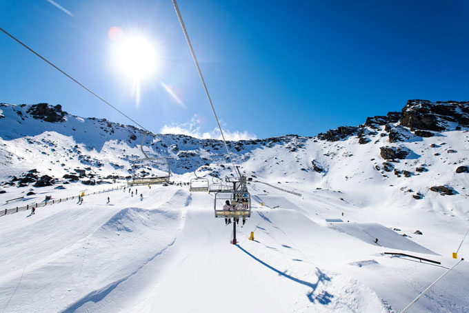
Spring doesn’t get much better than blue bird mornings and sunny park laps! Source:: The Remarkables
New Zealand Seasonal Snow Outlook | The Grasshopper
Brought to you by ESS Boardstores
The 2016 season in New Zealand has matured like a fine wine. After a mild and wet start to the season the snow started to pile up during the second half of July as a succession of fronts moved in from the west. However, Eastern Canterbury was still left thirsty for snow. August has worked its magic and equalised conditions across the country. A few much needed lows have tucked in to the east of the South Island driving up the base in the Canterbury High Country. Resorts closer to The Divide have also continued to receive a few top-ups keeping it funky ‘n’ fresh – but we haven’t seen quite as much snow as the second half of July. August’s cold temperatures have helped to maintain an excellent snow quality. We’ve also seen plenty of blue bird days between the storms which have given us plenty of time to appreciate some of the best views on the planet as a backdrop.
August Under the Microscope
The shift to snowier conditions in the east came early in the month. A low tracking over the northern half of the South Island drove heavy snow into Eastern Canterbury from the 3-5th of August. The sun came out to play from the 6th to 11th as high pressure reigned supreme. With very cold conditions and excellent natural snow we were basking in our own glory. A cold front moved in from the west on the 12th dishing out some light snow along The Divide before morphing into a weak low over the Cook Strait on the 13th. This drove additional snow into Canterbury. From the 16th to the 20th we saw a return to mostly fine conditions under a high. The high was booted out by a front moving in from the west on the 21st that bought some ugly r**n to lower elevations along The Divide. On the 24th a low brushing by to the west gave further snow to Otago before Canterbury got its turn on the 26th wrapping up what was a varied month for all.
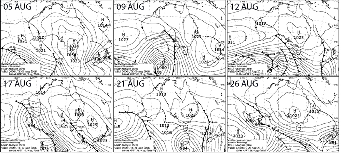
Synoptic maps summarising the key weather events to affect New Zealand last month. Source:: BOM
So just how much snow do we have?
The snow base depth is remarkably even across the South Island. Treble Cone (122cm/152cm), The Remarkables (100cm/140cm) and Mount Hutt (123cm/143cm) will head into spring on an even footing. These kind of depths are more or less average for the time of year but fall short of last year’s snow bonanza along The Divide. Meanwhile across the Cook Strait snow depths in the North Island are drool-worthy. Whakapapa has an upper mountain base of 237cm. Last year’s act is hard to follow but it is still above average.
Whatever did happen to La Nina?
A weak La Nina was on the cards this winter but it never really got going – neutral conditions have persisted into August. The international climate model guidance suggests that neutral conditions will persist into spring. This gives us a slightly higher chance of easterlies compared to either La Nina or El Nino years. Positive Sea Surface Temperature (SST) anomalies around New Zealand have cooled over the last month which is good news. However, they remain weakly positive in the Tasman which has a pocket of much warmer water off the coast of South East Australia. The background climatic drivers are giving off a weak signal as to what we can expect in September. So, let’s take a look at the models to get an idea of what could happen as we move into the home stretch.
Model Forecast
A low, which will bring heavy rain to Australia, is forecast to head our way during the first week of September. It will bring mild northerly winds and rain to The Divide with lesser amounts further to the east. A cold front should move in from the south-west around the 6th giving us a chance of snow and kicking out all of the mild yucky air. A high will then dominate until the 10th. Beyond that, the models are hinting at another low moving in from the Tasman bringing further rain to The Divide with a colder and snowier period on the cards around mid-month.
Final Words
We have a month or two left in the season. As a general rule we can expect temperatures to slowly increase as we go into the second half of September. Mixed precipitation or rain will become a lot more likely over the next few weeks.
The model forecast for the first couple of weeks of September is not overly optimistic. However, even taking into account the rain I don’t foresee any major problems. We have enough snow on the ground to cruise into the end of the season in style. In my first seasonal outlook of the year I forecast a slightly worse than average season. I am happy to see that things turned around in the end. The season has been average overall but we’ve had some great days thrown in the mix.
This is my final seasonal outlook for the year, but you can follow my daily forecasts until October 2, when I’ll say sayonara until next season. If you’ve got a different idea on what’s going to happen during spring, or just want to provide feedback, then please join in the discussion below, or hit me up at grasshoppermw@gmail.com or join the discussion below.
The Remarkables forecasts,
snow reports and
live snow cams.
Treble Cone forecasts,
snow reports and
live snow cams.
Snow Park forecasts,
snow reports and
live snow cams.
Cardrona forecasts,
snow reports and
live snow cams.
Turoa forecasts,
snow reports and
live snow cams.
Coronet Peak forecasts,
snow reports and
live snow cams.
Whakapapa forecasts,
snow reports and
live snow cams.
Mount Hutt forecasts,
snow reports and
live snow cams.


