Weekly North American Forecast, Dec 23rd – Cold Snap in the North to be Replaced by a Barrage of Warm, Moist Storms
Mountainwatch | The Grasshopper
Written Thursday December 22nd(Pacific Standard Time)
The next couple of days will see the cold snap in the North replaced by a barrage of warm, moist storms, as a monstrous low-pressure system churns away in the North Pacific Ocean, pushing in a S-SW flow that stretches all the way back to Hawaii.
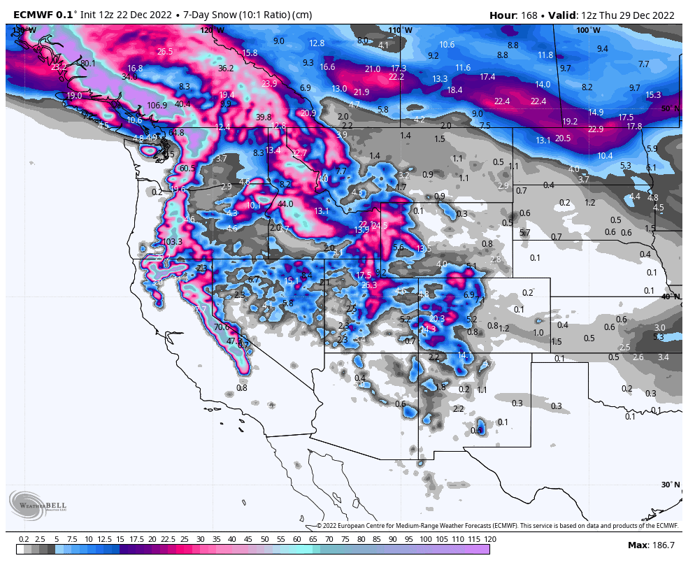
This weather regime will continue through Christmas weekend and into the new year, bringing a messy, heavy mix of rain, sleet and snow, especially to the Pacific Crest. Nonetheless, snow accumulations will be massive over the next seven days along the Pacific crest and northern Rockies as shown in our chart below.
Thursday December 22nd– Friday December 23rd
Thursday has started dry across the North American west after a freezing arctic airmass pushed south over Canada and down across the Pacific NW into the northern parts of Utah and Colorado. Temperatures behind this cold front will be down to -20°C to -30°C in many places!
However, the next couple of days will see a regime change, as a warm front rolls in from the Pacific later today, marking the leading edge of a warm, moist S-SW flow that stretches all the way back to Hawaii.
Heavy snowfalls are expected to spread inland from the Pacific NW to the northern Rockies, with the far southern reaches of the storm providing a few light snow showers down over Tahoe and northern Utah and Colorado. However, as temps warm up, rain and/or wet heavy snow will start to affect the lower slopes of resorts along the Pacific Crest.
Saturday December 24th– Sunday December 25th
The next storm front rolls over the Pacific NW and northern Rockies during Saturday, bringing even warmer air off the Pacific with heavy falls of a messy mix of rain, sleet and snow.
The storm will start to settle down later on Saturday with snow mostly clearing for a lovely, but perhaps not so white, Christmas morning. It’ll be a short-lived break, before the next front hits the Pacific NW and Canadian Rockies later on Christmas day, with the same heavy messy mix in store.
Monday December 26thto Wednesday December 28th
The storm that started during the second half of Christmas day will continue through Monday. The southern edge will reach down to Tahoe late Monday, before pushing further south over the rest of the Sierras and over the central and southern Rockies during Tuesday, with very heavy falls, especially in the Sierras.
This extra push southwards will be provided by a low, which crashes into the Pacific NW Tuesday night and will thankfully introduce slightly colder air into storm, dropping snow levels substantially.
The storm will start to abate during Wednesday with snowfall clearing the Sierras and easing along the Rockies.
Next Thursday December 29th& Beyond
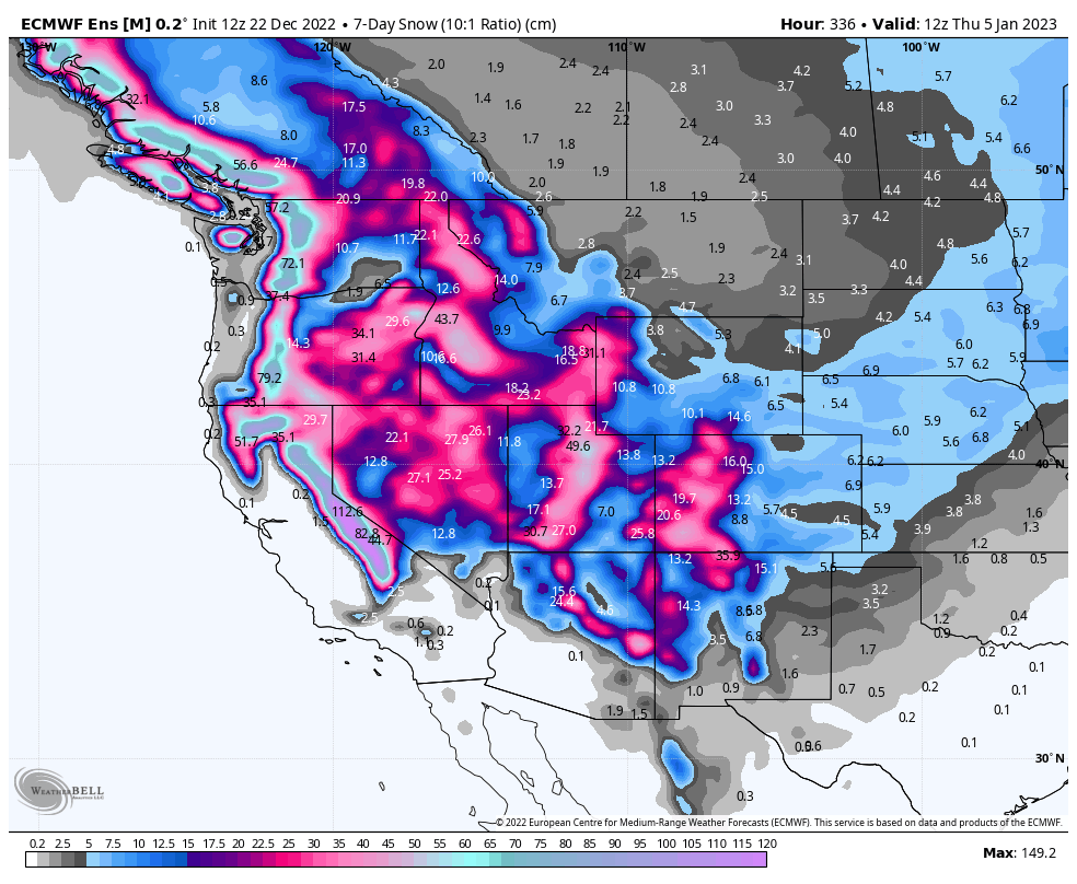
From next Thursday onwards, the same weather pattern looks to continue as the monstrous low-pressure system over the North Pacific keeps churning away, sending mostly warm, moist S-SW winds over the North American west. Multiple embedded fronts in the flow will bring waves of wet, heavy snow storms, with big numbers showing up in the weekly snowfall totals.
Cooler temperatures should show up during the first week of the New Year, as the storm centre in the North Pacific moves eastwards onto the Alaskan coastline.
Well, that’s all from me this week guys. Have a great Christmas, go get amongst and I’ll see you next Thursday.


