New Zealand Forecast – Winter Lets Rip Again with an Icy Blast & Fresh Powder
Published early Wednesday, 29th July 2026
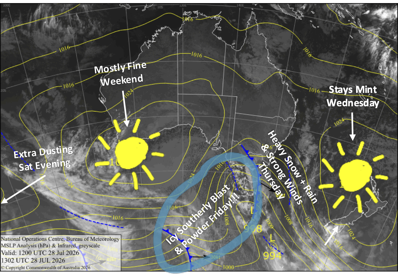
A mint Wednesday gives way to a stormy end to the week as an active front sweeps up the country on Thursday, bringing heavy rain, high-altitude snow and howling northwest winds. Keep an eye on lift ops, especially in Canterbury where severe gales may force closures.
Snow levels will initially be on the high side, but colder air sweeping in behind the front will send snow down to very low levels on Friday, with some roads likely affected. The Southern Lakes should score around 5-15cm of quality powder, while Canterbury gets a smaller top-up as an icy southerly blasts through Friday afternoon. Mt Ruapehu looks to be the big winner, with a solid 10-35+cm dump possible.
Temperatures stay nice and chilly this weekend, with nicer, more settled weather either side of an extra dusting for the South Island Saturday evening.
Wednesday 29th July
A fine day for the South Island with some cloudy spells, especially the Southern Lakes, while northwest winds strengthen.
An absolute stunner up on Mt Ruapehu with clear, sunny skies. It’ll be a calm morning before a light northwest breeze develops in the afternoon.
Thursday 30th July
A stormy day for the South Island as an active front from the west moves northwards up the country. Rain and mid-to-high altitude snow spreads over the Southern Lakes during the morning and Canterbury in the afternoon, with heavy falls as the front passes over.
Snow levels are tricky, but we should see snow fall to mid slopes, and possibly even the lower slopes of the Southern Lakes, while Mt Hutt will likely just cop rain. Northwest winds will blow like mad, reaching severe gale in Canterbury where we’ll be lucky to see any lifts running.
Conditions back off behind the front and snow levels creep down, with lighter snowfall reaching base levels in the Southern Lakes during the evening.
Conditions will also gradually deteriorate on Mt Ruapehu as northwest winds strengthen and clouds increase ahead of a front crossing overnight, bringing heavy snowfall to mid and upper slopes, but rain lower down.
Friday 31st July
The Southern Lakes will continue to see snow showers through much of the day, totalling around 5-15cm of high-quality powder to very low levels and affecting some roads, as strong southwesterlies turn to an icy-cold southerly.
Skies will be mostly clear in Canterbury during the morning as strong northwest winds ease and turn southwest. The strong, icy-cold southerlies whip through during the afternoon, bringing a small shot of powder to very low levels before clearing at night.
Snow continues on Mt Ruapehu, lowering to base levels in the morning as westerly winds shift to a colder westerly. A southerly change hits overnight, and then the snow will quickly peter out, leaving a solid 10-35+cm coat of fresh powder.
Saturday 1st August
A partly cloudy day for the Southern Lakes and a clear, sunny one for Canterbury with icy-cold southwest winds. A stronger surge of southwest winds scoots northwards in the evening, giving ski fields an extra dusting of snow.
Icy-cold southerlies on Mt Ruapehu will keep it partly cloudy, and there may be a few more snow showers too.
Sunday 2nd August
A fine start for the South Island, but clouds build over the Southern Lakes in the morning and Canterbury in the afternoon as westerly winds strengthen. Most of it will be high cloud.
Cloud clears Mt Ruapehu for a fine day as cold southerlies ease and turn southwest.
Extended Forecast
Another one or two quick-fire cold fronts shooting up the country should bring another dusting or top-up to Kiwi ski fields early next week, between Monday the 3rd and Thursday the 6th of August. Models are in sixes and sevens over what exactly will transpire, but we can at least expect a period of cold, settled, high-pressure weather after the passage of the front or fronts, providing a great window for snow making. The weather after this point is still up in the air, so we’ll wait till closer to the time before making any calls.
That’s all from me today, folks. I’m sending out NZ forecasts every Monday, Wednesday and Friday throughout the season. Have a great couple of days, and I’ll see you back here on Friday.
Grasshopper