Australian Forecast – Cooler Temps Friday & the Weekend to Bring a Little Snow Up High
Published early Friday, 19th June 2026
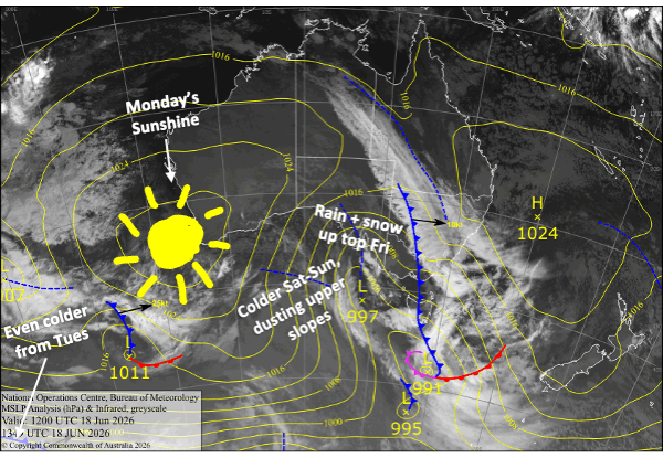
The warm, humid northerly flow of the last few days has been rough on our struggling snowpack, with rain also giving it a soaking on Thursday. Fortunately, that’s all behind us now, and a cooler airmass arriving today, Friday, will see snow falling about the tops before lowering to around 1700-1800m later on Saturday. The snow/rain will clear up on Sunday, and we should’ve scored several centimetres of snow up top and a dusting a bit lower down.
Another weak cold front brushing past us on Tuesday will bring a light snow shower or two, but mostly, it’ll provide great snowmaking conditions over the following couple of days as resorts look to rebuild.
Friday 19th June
Rain at times with strong, gusty northwest winds. Snow will start falling about the tops above 1800-1900m in the afternoon as a cooler airmass arrives.
Saturday 20th June
Another wet one, but rain will be lighter than the day before, with snow falling about the tops again. Temps will continue to cool slightly, so snow levels should eventually dip to around 1700-1800m. West-northwest winds ease, then a light southerly develops in Victoria.
Sunday 21st June
Rain and drizzle, falling as snow to 1700-1800m, gradually clears from the west during the morning, but a few extra showers could pop up in the afternoon as clouds start to break up. Light breezes from the southeast.
Monday 22nd June
A fine day with a light southwest breeze, but there’ll be a bit of cloud about, especially in Victoria. It’ll be nice and chilly overnight for the snow guns.
Tuesday 23rd June
Skies will be mostly clear at first, but a weak cold front brushing past will bring cloud and stronger, colder southwest winds, then a light snow shower or two later. It’ll be a good night for making snow.
Extended Forecast
The resorts will have a good chance to pump out man-made snow during Wednesday and Thursday, the 24th and 25thof June, while cold southerly winds gradually ease and skies clear.
Northerly winds will pick up again next weekend, the 27th and 28th of June, with more rain likely. Cooler temps early the following week, from about Monday 29th June to Wednesday 1st July, could see some snow falling up high again, maybe to lower levels if we’re lucky, but it’s nothing to get too excited about at this stage.
Models show a more favourable storm system approaching early July, but that’s still way off in imagination land, so we’ll have to wait and hope it’s not a fizzer.
That’s all from me today, folks. I’m sending out these forecasts every Monday, Wednesday and Friday throughout the season, and during July and August I’ll fire one out on Sundays too. Have a great weekend, and I’ll see you back here on Monday.
Grasshopper