Grasshopper’s 2026 Australian Snow Season Outlook – June Update

Mountainwatch | The Grasshopper
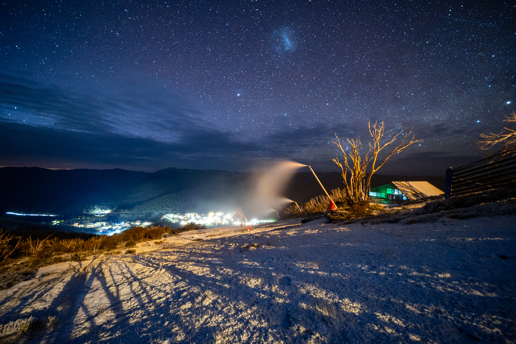
Welcome back to another Australian seasonal update, and although it might not yet look like it, we are a few weeks into the snow season. Despite some early falls and optimism things have been warm and the few storms that have rolled through were rather wet. So, let’s revisit what our expectations were for this winter below as we dive back into our seasonal outlook.
Short Term Update
If you have been keeping up to date with the weekly forecasts, you’ll know that there isn’t a huge amount to report. A front/trough system approaching from the west this week is largely all bark to bite and will weaken thanks to the high-pressure system over the southeast.
But, looking a little further ahead to the second half of next week, there is a chance for some more wintery weather kick off July. At this stage we should see a low-pressure system form in the Bight and move across the southeast of the country, making its presence felt over the Alps from Wednesday/Thursday. This one will start out wet with cooler temperatures and snowfalls continuing over the following weekend. We are still a way out, if things turn out positive a conservative number is 20-50cm which could help much needed bases.
The NSW Main Range is most likely to fair the best with totals above 50cm possible. Stay tuned for updates on this in my forecasts as things become clearer.
It’s Official
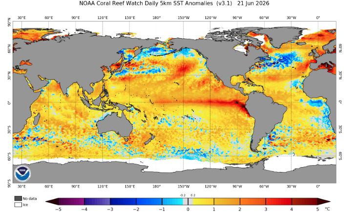
An El Nino event has now been officially declared by the Bureau of Meteorology which is the earliest declaration in BOM history. It has also been declared by several other national agencies. The news should come as no huge surprise, but a declaration this early is significant. ENSO events typically peak in strength during the southern hemisphere summer but in Australia the impacts are felt most during the southern hemisphere winter/spring. Below we have a current snapshot of the global SST anomaly with some obvious red areas in the central-eastern equatorial Pacific indicative of an El Nino.
Climate drivers have been pointing to a potentially very strong El Nino this year, this continues to be the case with SSTs (Sea Surface Temps) in the nino3.4 region expected to continue to rise throughout the year. Below is a forecast plot from the Bureau of Meteorology and another showing a few of the other major agencies. I’ve added a line at 0.8 on the second plot for reference showing how we are still very much on the upward trajectory.
Also note that the strongest El Nino’s recorded have been around the 2.5°C mark in this region, which aligns with some of the mean foretasted values on the plot below. I reckon we are looking at a very strong result this year, potentially challenging records. The descriptions “Super El Nino” and even “Godzilla El Nino” have been thrown around lately. Despite such hyperbole, the hard part is that the relationship between the SST anomaly in the actual impacts of an event is non-linear, so let’s get back to some more investigations in our own backyard.
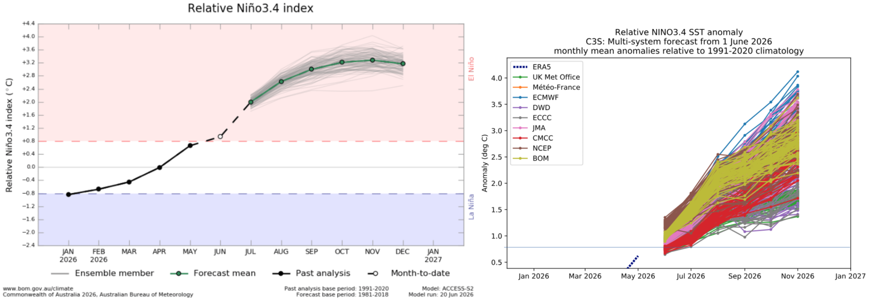
Two plots forecasting the evolution of the nino3.4 index over the coming months. The Bureau of Meteorology’s forecast (left) showing the previous trend, and a combination of met agencies compared (right) featuring a horizontal line at 0.8 for reference. Source: Bureau of Meteorology and Copernicus Climate Change Service.
Where to from here?
It’s not great news, with not much change over the next three months to the most likely outcome from the past 2026 season outlooks. We spoke about the impact of a wrong’un El Nino like we have seen in some years like the 2015 season, but most signs are leaning towards a traditional strong El Nino event which means warmer and drier conditions are the most likely outcome for the southeast of the country. This is because an El Nino promotes clearer conditions dominated by strong high-pressure systems that act to keep the wild winter weather to the south.
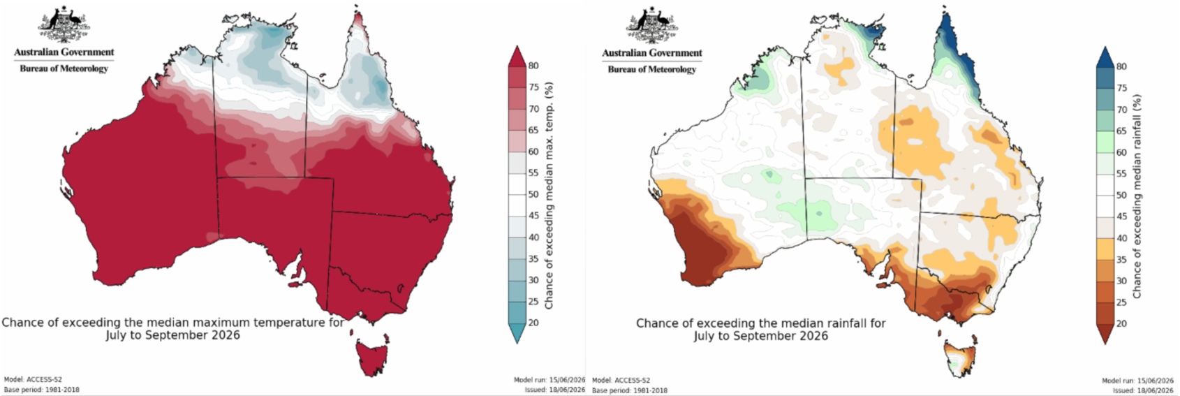
Below are the three-monthly forecasts for temperature (left) and precipitation (right) from the Bureau of Meteorology backing this up. Widespread high likelihood of warmer than median max temperatures across the country coupled with reduced chances of rainfall across the Alps make for a less-than-ideal set up when we want to get out and hit the hill.
However, while it is unlikely we are going to be in for a bumper year it is worth remembering that a late start to the Australian season is not exactly rare. Mother nature has a way of making us impatient, but this season is going to come down to a handful of storms that will have the potential to make or break the season.
Wrap Up
One more month down and we unfortunately haven’t got any new information that may have changed the overall picture. A potentially very strong El Nino looks to leave its mark on the Australian snow season, acting to suppress the volume and frequency of snow-bearing storm systems on the Alps. This makes us much more dependent on a few big storm systems to break through during most likely lengthy periods of clear weather. There is potential for the first of those storms to arrive next week.
Check my regular forecasts to see how it may pan out. Also, stay up to date on actual on-the-ground conditions with our daily independent snow reports.


