Grasshopper’s North American Forecast – Mild and Stormy In The Northwest, Sunny in The Sierras, A Couple of Quality Dustings In The Rockies Next Week
Mountainwatch | The Grasshopper
Valid Thursday 30thJanuary to Thursday 6thJanuary
Storms continue in the northwest where massive accumulations await upper slopes, but temps will be mild and buckets loads of rain will fall at low altitudes.
Those storms will penetrate inland where the northern Rockies face a similar fate. However, a freezing, cold front will swoop down this weekend and early next week, giving all and sundry a dusting, including the Sierras, which will be the only snowflakes they’ll see there in a mostly warm sunny week.
Canadian Coast Mountains & the Cascades
A mild southerly flow with embedded fronts will hammer the area over the next few of days. Precipitation will be heavy at times, but snow levels will be around 800m on Thursday, lifting to 1200-1600m during Friday, but 2000m or more in the Cascades.
Freezing air will thankfully file in later on Saturday, lowering snow to base levels, but snowfalls will also back off, then eventually taper off during Sunday and Monday.
Another bout of mild S-W winds and a couple of fronts will bring more heavy precipitation Tuesday through Thursday, but snow levels will again rise to mid-mountain.
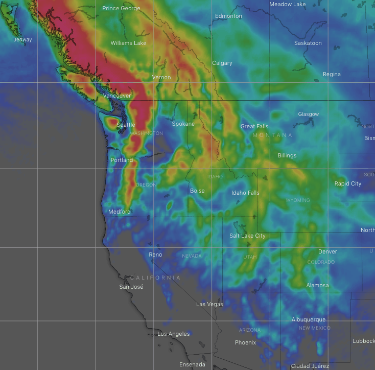
Sierra Nevada
The Sierras will sign off January and welcome in February with another quiet week full of mostly sunshine, warm temps, and high pressure.
However, a freeeezing, cold front will sweep down during the second half of Sunday, with snow showers giving the area a dusting of 5cm or less. Temps will remain cold during Monday before skyrocketing back up later on Tuesday.
The Rockies
A weak front will give the central Rockies a dusting during Thursday, after already giving the Rockies farther north one.
A front with mild S-SW winds will bring heavy snowfalls to the Canadian Rockies, and also briefly to northern Idaho and Montana, from Thursday night into Saturday, but snow levels will be uncomfortably high, and rain will reach mid-mountain or higher
Fortunately, a cold front will swoop in and save the day Saturday night and early Sunday, leaving 10-20cm of high-quality powder behind.
The cold front will continue southwards, reaching Wyoming and Utah late Sunday, and then briefly spins into a low to give those two states along with Colorado and New Mexico a good powdering during Monday.
Snow will eventually stop falling in Colorado and New Mexico during Tuesday as the next front sweeps down over the northern Rockies, dishing out some moderate to heavy snowfalls, and reaching the central Rockies on Wednesday with lighter snowfall instore.
Next Thursday will likely see another front and more snow over the northern Rockies.
That’s all this week guys, see you next Thursday.