North American 2021-2022 Snow Season Outlook – January Update
Mountainwatch |The Grasshopper
After some big falls through December and over the New Year things have quietened down a little throughout North America, particularly in the US. However, there’s no doubt been amazing conditions around many resorts so far this season, but can expect more amazing days throughout the many world class resorts Canada and the USA have to offer.
Current Situation
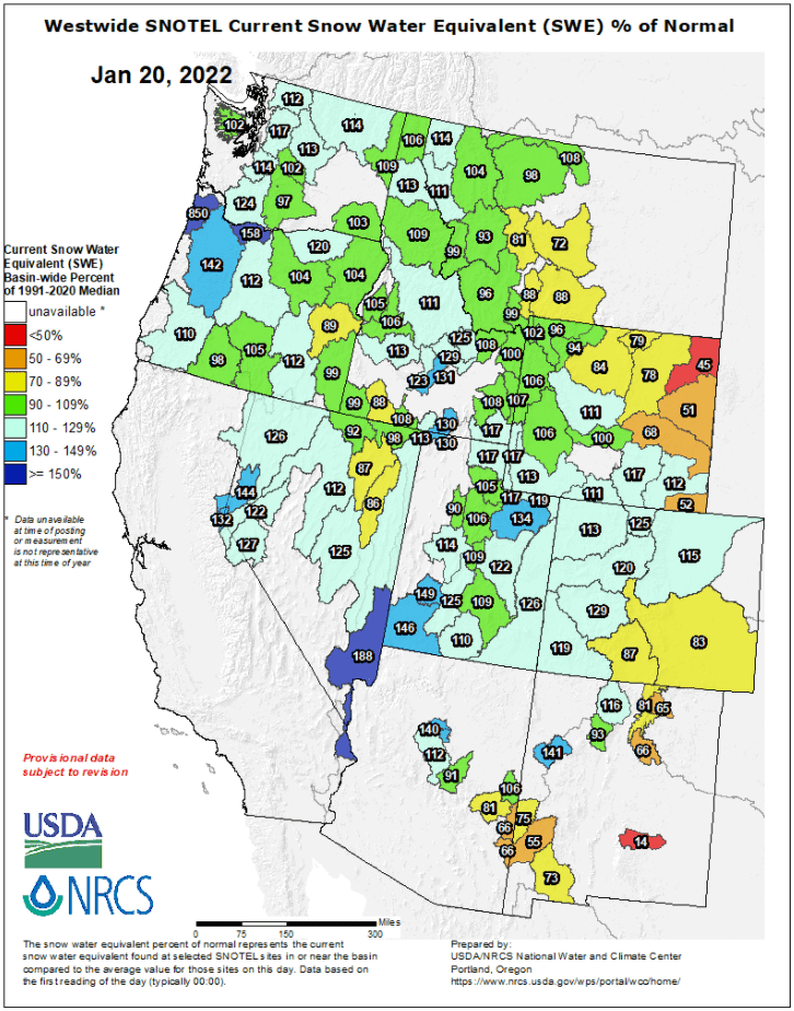
I have once again got the SNOTEL current snow water equivalent image below which shows the percentage of normal (1991-2020 median) around the western United States. From this we can see we have settled into this season well with the same image early in the season showing predominantly red, but now we have a predominantly green and blue trend. The theme of areas further south having a harder go of it than those up in the northwest is once again present – as we expected going into this season. Having said that this map is quite optimistic thanks to many greens and blues present in different areas.
End of Winter Outlook
With Spring just around the corner what can we expect for the end of winter? The latest NOAA (National Oceanic and Atmospheric Administration)three-month outlook for Feb-April is shown below and presents an image we have become familiar with this year thanks to La Nina’s influence. Below average temps and a better chance at above average precipitation for northwestern USA and western Canada, average chances through both central and western USA and finally below average chances for both temperature and precipitation further south. A slight difference in this outlook to those earlier in the season is the extent of how far north the above average temp and below average precipitation reaches. Areas like Utah and Colorado appear to have a slightly worse outlook than earlier in the season.
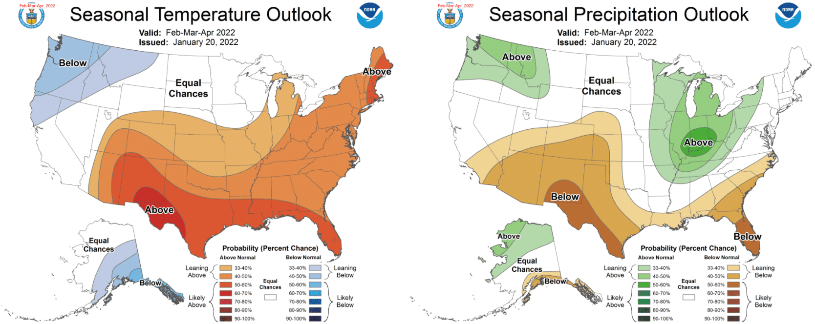
The most recent NOAA three-month outlook encompassing the February to April period. A similar signal to what we have become used to so far this season with a slightly worse outlook for central regions. Source: NOAA
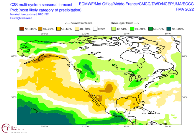
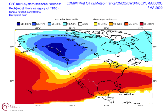
Continuing on with the seasonal outlooks I have the updated multi-system outlook for the Feb-Apr period. Below we have the precipitation outlook and which we see reinfornces the NOAA outlook. The best chances of above average percipitation are in northwestern USA and Western Canada. Again, the worst chances of above avreage is in the south and noticeably extending up into central areas.
The multi system temperature outlook for the February to April period is also included below, which shows a warm start to spring around central/southern areas which may not bode well for preserving the snowpack to enjoy some late spring skiing. This outlook is slightly worse for than the NOAA but it does feature a similar signature. Also, while we are on the topic of warmth there is a run of warm days on the way for areas around western Canada/northwestern USA, contributing to an increase in avalanche danger around multiple areas (not a great omen for the remainder of the season).
The Short Term
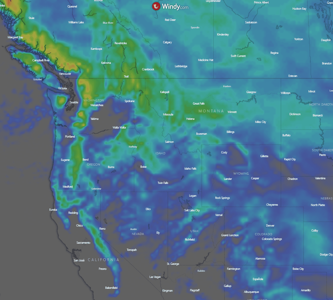
So, what can we expect from the next few days? Unfortunately, we aren’t expecting any monster storms to come through, but we should see some snow fall throughout multiple areas as we can see in the heatmap below. The heatmap shows the 10-day ECMWF model snowfall accumulations across North America and does show modest falls in a variety of areas. What this doesn’t tell you though is that most of this snow will come around the week of the 31st. Before then there is a period of warm temperatures next week which I briefly mentioned is not ideal for the snowpack. But once this warmer period is over the snowfalls coming around Monday week could be decent in some areas (particularly western Canada). I’ll keep an eye out and see how they develop in the coming days.
So, what’s going on?
Well in conclusion after a huge end of 2021 things have slowed down, and unfortunately in the short term there isn’t too much to be excited about. Looking through spring the outlook is quite similar to what we saw earlier in the season: areas in the northwest United States and western Canada are still the best placed to receive good conditions throughout the rest of the season. The bad news is for some of the regions throughout the western central United States where the outlook is not so bright.
Does this mean it will be a poor end to the season with no storms? Well no, as always, these three-month outlooks are quite probabilistic. We may still see some big storms close out the season through spring but the outlook, especially for the mountains further south, is for warmer temperatures and less precipitation on average, which never sounds good out loud.
Overall, if you are lucky enough to be around North American resorts right now, enjoy some undoubtedly great skiing. If you’re looking at escaping somewhere for a late season getaway it’s looking like the further north you go, the better.
That’s it from me folks. If you’ve got a different theory on what’s going to happen this winter, or just want to provide feedback, then please hit me up on the discussion below. Or you can follow me on Facebook.
Take care, Grasshopper


