SNOW HOLIDAY
ENQUIRY
The Grasshopper – The Latest Snow Forecast

The Grasshopper – The Latest Snow Forecast

Australian Forecast – Fine Weather Holds for the Weekend Before Storms Next Week

Published early Friday, 26th June 2026

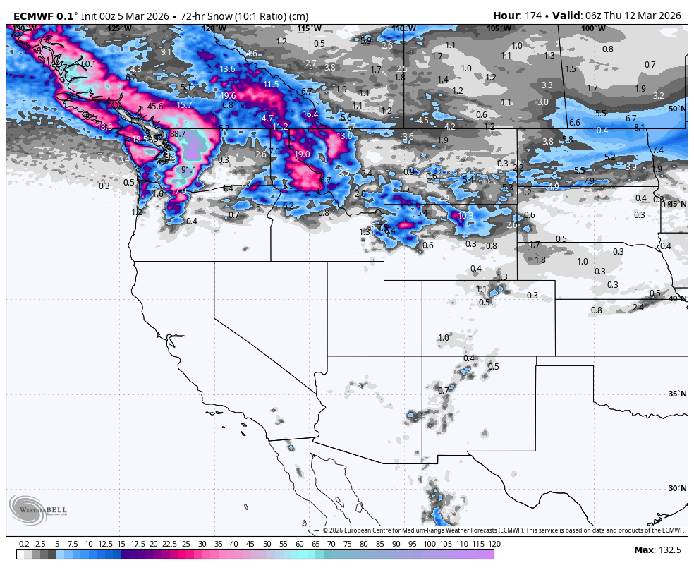
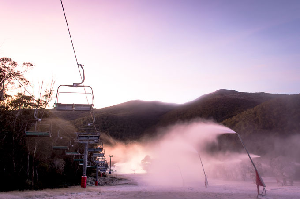
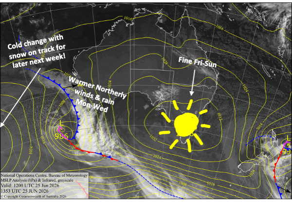
The settled spell will continue through the weekend as a large high-pressure system drifts eastwards over us. Snow-making conditions this week haven’t been as ideal as hoped, with humidity and temperatures running too high. However they had a good run last night and tonight and Saturday nights look more ideal for it, before milder northerlies arrive on Sunday, shutting down snowmaking opportunities for several days.

Rain and stronger northerlies are set to lash the Aussie Alps from Monday through Wednesday, but a cold change later next week is still on track to deliver snow and a change of fortunes.

Latest pressure analysis and satellite image. Source: The BOM (vandalised by the Grasshopper)

Friday 26th June

Another nice sunny day, with just a little cloud popping up in the afternoon and little to no wind. The snow guns will get another run overnight.

Saturday 27th June

A mint, calm and sunny day, with snowmaking temps again overnight.

Sunday 28th June

A clear start to the day, then clouds will build during the afternoon, especially in New South Wales, where there could even be a light shower or two. A milder northerly breeze develops, making it less likely for snowmaking overnight.

Monday 29th June

Rain at times with northerly winds. The rain will become more persistent and heavier at night as a front moves in from the north. Not what we need right now, as the snowpack will take another hit.

Tuesday 30th June

Another wet, rainy day with northerly winds.

Extended Forecast

Wednesday, the 1st of July, will be another wet one with strong, mild northerly winds. The snowpack will be a shadow of its former self, and June 2026 will infamously go down in the history books as one of the worst.

Fortunately, cold air is still on track to start piling in from around Thursday and Friday, the 2nd and 4th of July. Signs are looking good for snowfalls over a 2-3 day period, as well as a prolonged run of snow making – not exactly Blizzard of Oz 2.0, but hopefully enough to open up more terrain for the school holidays.

That’s all from me today, folks. I’m sending out these forecasts every Monday, Wednesday and Friday throughout the season, and during July and August, I’ll fire one out on Sundays too. Have a great weekend, and I’ll see you back here on Monday.

Grasshopper

New Zealand Forecast –  Saturday Gets the Green Light for Opening Day After Cold & Fresh Snow

Published early Friday, 26th June 2026

The Southern Lakes scored a tidy 10-15cm of fresh snow late Wednesday and early Thursday. The place is looking much whiter, and the ski fields have been making snow like mad Tahr billies in a rut.

Mt Hutt had received 5cm of snow from the initial round on Wednesday night, but it started snowing again around midday Thursday as the second, stronger, and colder southerly arrived. We’re expecting bigger totals in Friday morning’s report, so be sure to check that when it comes out. Mt Ruapehu will also have fresh snow to report.

With the improvement in conditions, The Remarkables, Cardrona and Mt Hutt have locked in this Saturday to open at last. The Southern Lakes will now have a run of fine weather and good snow-making conditions.

The tail end of the storm, with see northern Canterbury receiving another 5-15+cm today, Friday, and a little extra dusting for Mt Hutt and the Craigieburn ski fields. It’ll stay clagged in with cloud on Saturday, but it’ll be nice and fine from Sunday.

Latest pressure analysis and satellite image. Source: The BOM (vandalised by the Grasshopper)

Friday 26th June

A nice, fine day for the Southern Lakes as a cold southeast breeze eases. Apart from a wee break in the afternoon, the snow guns will get a lot of work done.

In Canterbury, light snow showers and flurries will continue into the afternoon for Mt Hutt and Craigieburn Range ski fields, where it’ll be clagged in with cloud. Snowfall will keep going strong in the north, benefiting the My Lyford and Hanmer Springs ski fields, before backing off in the evening. The snow guns will also get a good run here as strong, cold southerlies abate and turn southeast.

On Mt Ruapehu, snowfall will turn wet briefly before clearing in the afternoon as temps warm. Strong southerlies also abate and turn southeast.

Saturday 27th June

Perfect weather for Opening Day in the Southern Lakes, with clear sunny skies and a light southeast breeze. Great snow-making conditions continue morning and night.

Opening Day at Mt Hutt will be damp and humid with low visibility as east-to-southeast winds push cloud in at ski-field height throughout Canterbury. There’ll be some light leftover snowfall in northern Canterbury until the afternoon.

Strong southeasterlies on Mt Ruapehu will bring showers of rain, which will fall as snow up top.

Sunday 28th June

A mostly fine start for South Island ski fields, but southerly winds will see cloud increase in the afternoon. It should be cold enough for making snow at most ski fields, morning and night.

Southeast winds persist on Mt Ruapehu, with a few light rain showers falling as snow up top. A colder airmass arrives overnight, so the snow gun will be able to fire up.

Monday 29th June

Another mint, clear day for the Southern Lakes with little to no wind and good snow-making conditions morning and night.

Cloud in Canterbury clears in the morning or afternoon, and there’ll be light south-to-southeast breezes. The snow guns should get a run overnight.

Another day of southeasterly winds for Mt Ruapehu with partly cloudy skies.

Tuesday 30th June

South Island ski fields will have a clear sunny day as north breezes develop.

It’ll also be clear and sunny for Mt Ruapehu as the easterly breeze dies out at last.

Extended Forecast

The weather becomes unsettled again later next week, likely starting with a strong northwest rainband moving up the South Island during Friday, the 3rd, and Saturday, the 4th of July. Cold air is expected to start arriving from Sunday, the 5th  or Monday, the 6th, with models indicating good potential for a decent snowfall and a prolonged cold period. It’ll be just the boost we need to open up more terrain and get the season humming.

That’s all from me today, folks. I’m sending out NZ forecasts every Monday, Wednesday and Friday throughout the season. Have a great weekend, and I’ll see you back here on Monday.

Grasshopper

Weekly Japan Forecast – A Better Week Ahead With More Snow & Colder Temps

Written late Wednesday, 4th March (Japan Standard Time)

Well folks, this will be my final forecast for the 2025–2026 Japanese snow season. It’s been a solid month of limited snowfall and unseasonably warm temperatures across Japan, with the past seven days in particular delivering very little fresh snow. After an epic January and early February, the Japow machine has largely switched off, and we’ve seen considerable snow loss as a result.

However, the next seven days look far more promising, with a few decent rounds of powder and cold temps on the way. Thursday, Sunday and Tuesday are shaping up as the standout days, with the bulk of the snowfall expected then. There are still a few weeks left in the season, and spring skiing brings warmer temperatures, longer days and more sunshine. It’s my personal favourite, so get amongst it! 

Weekly snowfall accumulation, from Wednesday morning, the 4th, to Wednesday, 11th March. Note that snow depths here are calculated using a 10:1 ratio, where 1mm of rain equals 1cm of snow. This can significantly underestimate things here in Japan, where 1mm of rain often equates to 1.5-2 cm of snow owing to its light n’ fluffy nature. Source: ECMWF, WeatherBell.com

Thursday 5th & Friday 6th March

Thursday will be a powder day of sorts as remaining snowfall across the country gradually dries up. This comes after a storm from the southwest arrived late Tuesday, bringing warm temperatures and rain at first. Temperatures were quick to drop over Northern Honshu and Hokkaido, so there was fresh snow in this Wednesday morning’s reports. However, it was not your usual “lake-effect” Japow; it was denser, maritime snow coming off the Pacific Ocean, akin to what we get in Australia and NZ. As I put pen to paper, snow levels over Central Honshu are also on their way down from the mid-slopes and will get nice and low this Wednesday night.

Friday will stay mostly dry, but there’ll be some isolated flurries lingering on Hokkaido. Temperatures will rocket back up on Honshu as warm southerlies develop ahead of the next storm approaching from the west in the Sea of Japan. Rain from this storm spreads across the country Friday night, falling as snow to fairly low levels on Hokkaido, where temperatures will be much colder.

Snowfall accumulation from Wednesday morning to Friday. Source: ECMWF, WeatherBELL.com

Saturday 7th February & Sunday 8th March

The storm will continue over the country throughout Saturday and Sunday morning, then gradually wind down during the latter half of Sunday. Snow levels about the mid-to-upper slopes of Honshu will gradually lower to base levels by late Saturday, while on Hokkaido, they’ll have to climb over a hill before a period of heavy snowfall to near sea level early Sunday.

Snowfall totals for the weekend are expected to be around 20-50+ cm, with resorts in Niigata and southwest Hokkaido favoured for the deepest totals.

Snowfall accumulation for Saturday & Sunday. Source: ECMWF, WeatherBELL.com

Monday 9th to Wednesday 11th March

Leftover snow showers over northern Honshu will clear up Monday morning, but will persist on Hokkaido.

Central Honshu will stay dry on Monday, but another low-pressure system passing on the Pacific side will pull in a fresh surge of cold air from Monday night, bringing another round of snow for a 10-30+ cm powder day on Tuesday. The passing low will also bring a dusting to northern Honshu and Hokkaido on Tuesday.

A ridge of high pressure will then bring dry, settled weather next Wednesday.

Snowfall accumulation for Monday to Wednesday. Source: ECMWF, WeatherBELL.com

That’s all from me today, and for the season. It’s been a real pleasure bringing you all the snowlights of the 2025-2026 season, which will go down in the history books as having one of the best runs of powder days from Jan through early Feb. See you in June when the Aussie and Kiwi seasons get underway.

Grasshopper

Weekly North America Forecast – Temps Fluctuate as Storms Favour the North

Written Wednesday, 5th March (Pacific Standard Time)

Well, guys and gals, this will be my final forecast for the 2025-2026 North American snow season. It’s been a funny ol’ season that saw some Canadian resorts cranking through December with near-endless snowfall, followed by a long, warm, dry spell, which US resorts in particular suffered from as high-pressure took over the West, while the East went into a storm-laden deep freeze.

Storms returned to the West mid Feb, and resorts have had a great few weeks as snowpacks have bounced back. At present, snowpacks in the northern half of the Rockies, from Canada and Alberta down to Wyoming and Idaho, are sitting at or above their long-term median, highlighting where conditions have been the best this season.

Storms will once again favour the north in the upcoming seven-day period, although snow quality and snow levels will fluctuate as warm and cold airmasses are dragged in with each storm system. The central and northern US Rockies will also receive a nice round of powder at the start of this period (Thursday and Friday), before settled high pressure then takes hold over the central and southern US.

7-Day snowfall accumulation. Note that snow depths here are calculated using a 10:1 ratio, where 1mm of rain equals 1cm of snow. This can significantly underestimate things here in North America, where 1 mm of rain often equates to 1.5-2 cm of snow, especially in the Rockies, where it can be really light n’ fluffy. Source: ECMWF, WeatherBELL.com

Thursday 5th & Friday 6th March

A storm that arrived in the northwest on Wednesday will continue tracking southeast through the US Rockies on Thursday before exiting late Friday. The storm, which started wet and warm, will see snow levels drop as a cold front now leads the charge. Snowfall will favour northern Idaho, Montana, Wyoming and Utah on Thursday and then Colorado on Friday. Totals will mostly range between 15-40cm in the central and northern US Rockies, with 40-50+cm possible in the most exposed terrain, particularly in Montana.

Leftover snow showers will give BC and the Cascades a further dusting before the storm exits the area on Thursday. But a new storm entering the northwest from late Thursday through Friday will bring a mix of rain and dense snow as a warm, humid air flows in from the Pacific. The bulk of this will fall in northern BC, with only light falls in southern BC, where most resorts are located.

Having received a few showers on Wednesday, Tahoe and the Sierra Nevada will stay dry for Thursday and Friday, while Arizona and New Mexico will only get a light dusting in their northern parts.

Snowfall accumulation for Thursday & Friday. Source: ECMWF, WeatherBELL.com

Saturday 7th & Sunday 8th March

This weekend, all the action will take place in the north. The warm storm that arrives here on Friday will become colder on Sunday as a cold front pushes down from the north. Once the cold front hits, snow levels will drop, and snow quality will improve.

Interior BC, the northern Cascades, and to a lesser extent, Alberta, will be favoured for the biggest accumulations of this quality powder during the latter half of Sunday, while Idaho, Montana and Wyoming will also see snow developing ahead of the cold front on the warm side of the storm.

Snowfall accumulation for Saturday & Sunday. Source: ECMWF, WeatherBELL.com

Monday 9th to Wednesday 11th March

Most of the action continues in the north during this period, with the cold front pushing down into southern Idaho and Wyoming during Monday, where it’ll stall for a while. Areas north of this will be treated to light-to-moderate falls of smoky powder on Monday and Tuesday.

But on Wednesday, temperatures and snow levels will rocket up as a new, warmer storm enters the fray, bringing heavy low-to-mid-level rain and upper-level snow. The northern Cascades, in particular, are expected to get nailed. Thankfully, this injection of warm, humid air will be short-lived, and by the end of the day (Wednesday), temperatures will be hastily making their way down.

In the south, a weaker storm system will track over Arizona and New Mexico on Monday and Tuesday. Temperatures will be warm, so it’ll be a mix of rain and snow for resorts there. If we’re lucky, some resorts could see moderate accumulations on their upper slopes.

Snowfall accumulation for Monday to Wednesday. Source: ECMWF, WeatherBELL.com

That’s all from me today, and for the season. It’s been a blast and a pleasure being a part of it all. See you all in June when the Aussie and Kiwi seasons get underway.

Grasshopper

Latest Outlooks

1 64 65 66