2022-2023 North American Snow Season Outlook – January Update : Active Pattern to Give Way to a Fading La Nina
Mountainwatch | The Grasshopper
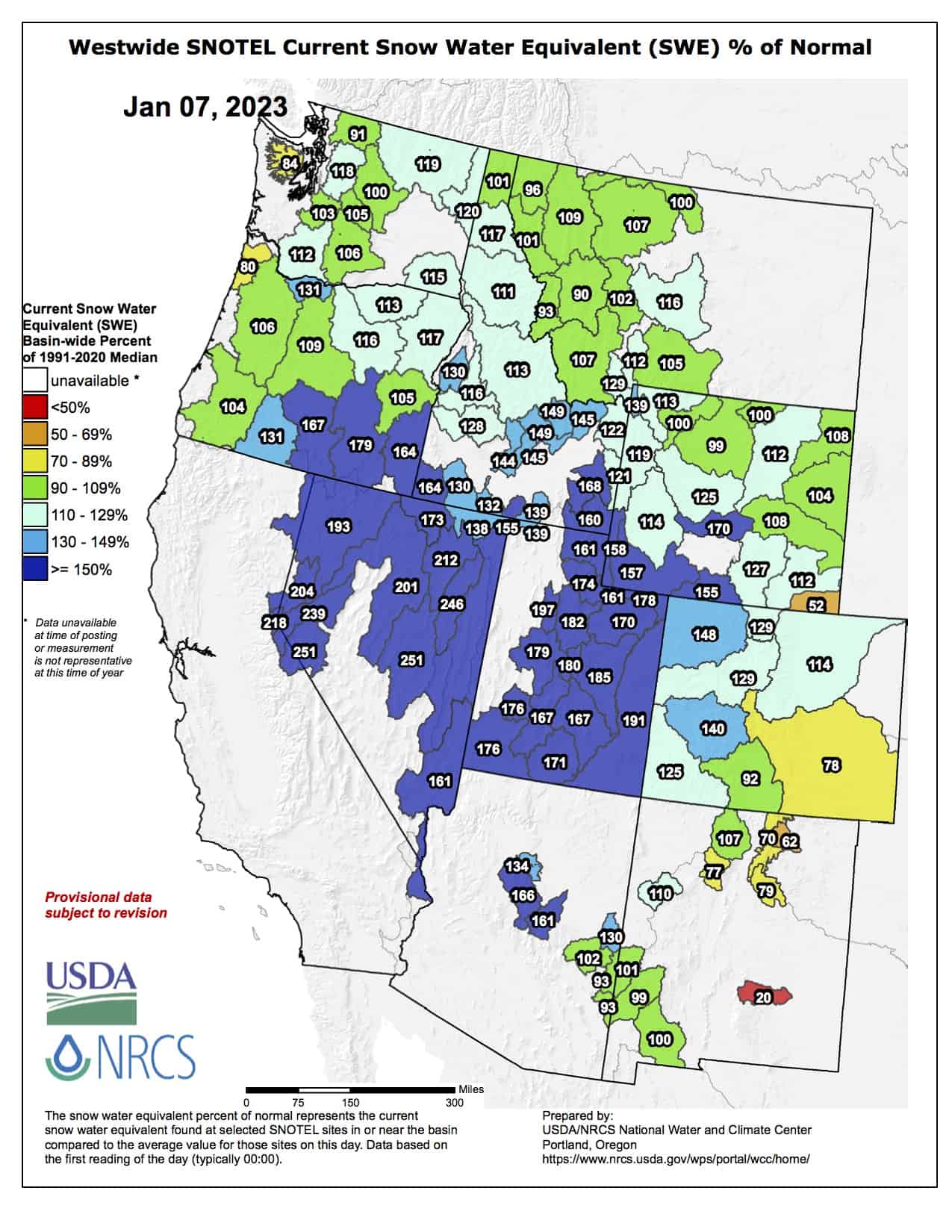
It’s been one heck of a start to the season for resorts in the U.S., especially for those in California and Utah where snow depths range between 150-250% of their average for this time of year. The percentages start to shrink as you look north, where resorts in the Canadian Rockies are getting by on rations, particularly in Alberta where snow depths are well down.
The first half of December was nice and stormy, especially south of the Canadian border where a tonne of snow fell in the Sierras and central Rockies. Things then went relatively quiet for a while as high pressure dominated, and we saw the Big Freeze descend down from the Arctic over the Pacific Northwest and through the Rockies, with temperatures of -20°C to -30°C or lower in many places.
Just as everyone was packing for the Christmas holiday, there was a major shift in the weather regime. A whole heap of pent up energy in the North Pacific came knocking at the door, setting up atmospheric rivers of warm, moist air extending as far back as Hawaii. It started in the northwest, then migrated southwards and inland. Big numbers were showing up, especially along the Pacific Crest, where there was often rain mixed in at lower elevations, as well as in the central Rockies.
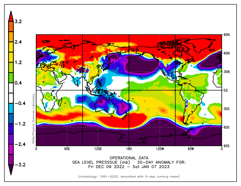
This weather regime has continued through the first week of January, and is expected to persist for at least the coming week or so. Big precipitation anomalies are showing up in the Pacific Northwest and Sierra Nevada’s again, as well as in the central Rockies, where resorts in the Wasatch Ranges (Utah) and those in the Boise region (Idaho) are looking particularly juicy. The Canadian Rockies will unfortunately remain relatively quiet, especially on the Alberta side.
January Forecast
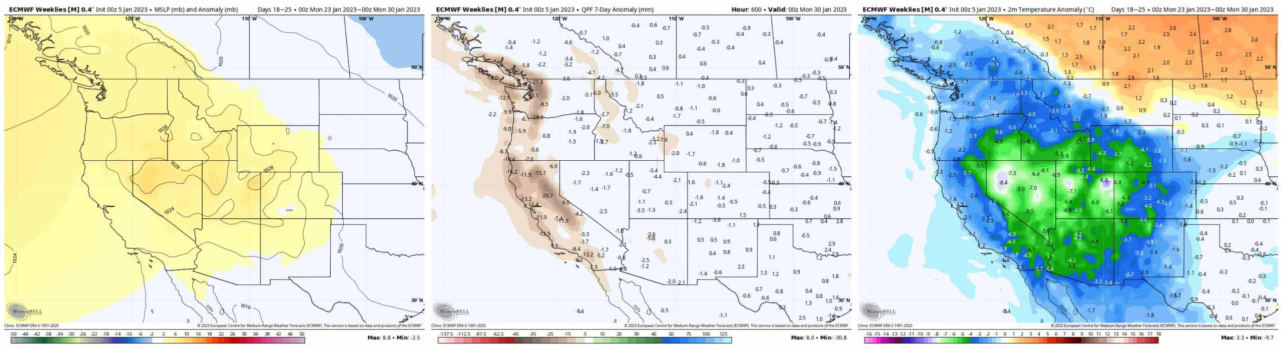
Stretching models and ourselves out as far as they’ll go to look further ahead into January, temperatures are expected to drop throughout the entire West next week before precipitation figures dry up later in the week as high pressure moves in. Ensemble models expect this settled cold, dry pattern will persist through the final week of January in what could be a nice break from all these storms, providing a chance to get in some fair-weather turns.
February, March & April Outlook
From February onwards, models generally slip back into the classic La Nina Pattern, which tends to favour the north-central resorts more than the south. Either due to La Nina fading away, or due to uncertainty creeping into models the further out we look, or simply because we leave behind the winter pattern, this north-central favouritism gradually drops away as we as we head into March and April and we’re left to the behest of the snow gods and their random acts of powder.
The weather regime of the last couple of weeks, as well as the week ahead, has been more El Nino-like rather than La Nina-like, with the south favoured for snowfall. However, the past doesn’t necessarily reflect the future in this weather game. If you remember last season – a La Nina by the way – Mammoth copped just over 4m of snow during December, but then received zero during January. That’s zilch, nothing, nada! It then only recoded about 18cm in February and 35cm in March – talk about a change in fortune!
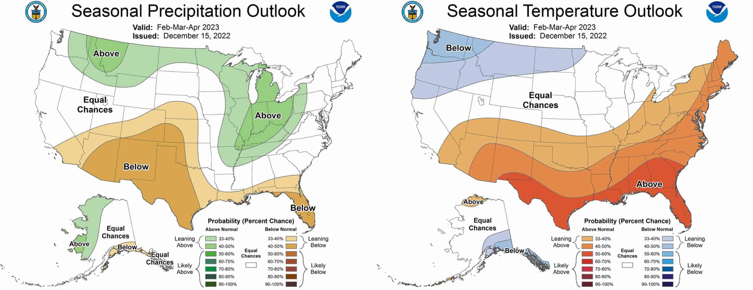
A change in fortunes to a more typical La Nina pattern is supported by the latest seasonal outlooks from the respective meteorological agencies of the U.S. and Canada, albeit without a strong showing of cold temps in Canada.
Wrap up
So, there we have it folks. Resorts across the U.S. are having a ripsnorter of a season so far, and that looks set to continue for the next week or so with an active storm cycle continuing to favour the Pacific Crest, as well the central-southern Rockies.
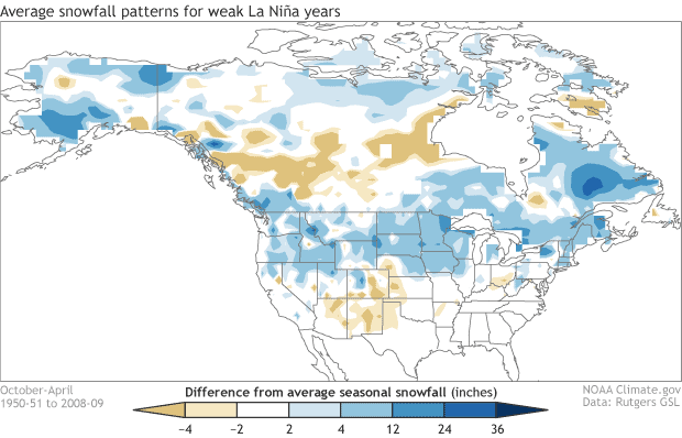
After a nice settled spell to finish off January, we can reasonably expect to slip into a La Nina pattern for the remainder of the season, albeit a weak and fading one. This generally favours the north, but during weak La Nina years the Canadian Rockies often don’t fare so well. Who knows, if the Albertan’s keep up their snow dancing, the snow gods may take notice as they come more into play later in the season.
That’s it from me folks, if you’ve got a different theory on what’s going to happen this season, then hit me up on Facebook. I’ll issue the next North American Outlook at the start of February. Until then, keep up to date with all the highlights and snowlights with my weekly forecasts issued every Thursday Pacific Standard Time.
Grasshopper


