SNOW HOLIDAY
ENQUIRY
Toggle navigation
Forecasts
AUSTRALIA
NEW SOUTH WALES
Thredbo
Perisher
Jindabyne
Charlotte Pass
Selwyn Snow Resort
Victoria
Falls Creek
Mt Hotham
Mt Buller
Mount Stirling
Mount Baw Baw
Lake Mountain Resort
Tasmania
Mount Mawson
Ben Lomond
New Zealand
Queenstown
The Remarkables
Coronet Peak
Queenstown
Wanaka
Snow Farm
Mount Aspiring
Cardrona
Treble Cone
Wanaka
Canterbury
Mount Hutt
Porters
Mount Olympus
Mount Cheeseman
Broken River
Craigieburn
Temple Basin
Hanmer Springs
Mount Lyford
Ruapehu
Whakapapa
Tukino
Turoa
Japan
Hokkaido
Niseko
Rusutsu
Furano
Kiroro
Honshu
Okunakayama Kogen
Hakuba
Nozawa Onsen
Myoko Kogen
Shiga Kogen
Madarao Kogen
Appi Kogen
Shizukuishi
Karuizawa
Mount Naeba
Hakkaisan
Manza Onsen
Hachimantai
Hakkoda
Tazawako
USA
Wyoming
Jackson Hole
Utah
Snowbird
Park City
Colorado
Beaver Creek
Vail
Steamboat
Breckenridge
Aspen Snowmass
California
Palisades Tahoe
Mammoth
Heavenly
Canada
British Columbia
Whistler Blackcomb
Big White
Revelstoke
Sun Peaks
Kicking Horse
Silver Star
Fernie
Alberta
Banff Sunshine
Lake Louise
Europe
France
Val d'Isère
Switzerland
Verbier
Austria
St Anton
Italy
Cortina d'Ampezzo
Snow Cams
AUSTRALIA
NEW SOUTH WALES
Thredbo
Perisher
Jindabyne
Charlotte Pass
Selwyn Snow Resort
Victoria
Falls Creek
Mt Hotham
Mt Buller
Mount Stirling
Mount Baw Baw
Lake Mountain Resort
Tasmania
Mount Mawson
Ben Lomond
New Zealand
Queenstown
The Remarkables
Coronet Peak
Queenstown
Wanaka
Snow Farm
Mount Aspiring
Cardrona
Treble Cone
Wanaka
Canterbury
Mount Hutt
Porters
Mount Olympus
Mount Cheeseman
Broken River
Craigieburn
Temple Basin
Hanmer Springs
Mount Lyford
Ruapehu
Whakapapa
Tukino
Turoa
Japan
Hokkaido
Niseko
Rusutsu
Furano
Kiroro
Honshu
Okunakayama Kogen
Hakuba
Nozawa Onsen
Myoko Kogen
Shiga Kogen
Madarao Kogen
Appi Kogen
Shizukuishi
Karuizawa
Mount Naeba
Hakkaisan
Manza Onsen
Hachimantai
Hakkoda
Tazawako
USA
Wyoming
Jackson Hole
Utah
Snowbird
Park City
Colorado
Beaver Creek
Vail
Steamboat
Breckenridge
Aspen Snowmass
California
Palisades Tahoe
Mammoth
Heavenly
Canada
British Columbia
Whistler Blackcomb
Big White
Revelstoke
Sun Peaks
Kicking Horse
Silver Star
Fernie
Alberta
Banff Sunshine
Lake Louise
Europe
France
Val d'Isère
Switzerland
Verbier
Austria
St Anton
Italy
Cortina d'Ampezzo
Snow Reports
AUSTRALIA
NEW SOUTH WALES
Thredbo
Perisher
Jindabyne
Charlotte Pass
Selwyn Snow Resort
Victoria
Falls Creek
Mt Hotham
Mt Buller
Mount Stirling
Mount Baw Baw
Lake Mountain Resort
Tasmania
Mount Mawson
Ben Lomond
New Zealand
Queenstown
The Remarkables
Coronet Peak
Queenstown
Wanaka
Snow Farm
Mount Aspiring
Cardrona
Treble Cone
Wanaka
Canterbury
Mount Hutt
Porters
Mount Olympus
Mount Cheeseman
Broken River
Craigieburn
Temple Basin
Hanmer Springs
Mount Lyford
Ruapehu
Whakapapa
Tukino
Turoa
Japan
Hokkaido
Niseko
Rusutsu
Furano
Kiroro
Honshu
Okunakayama Kogen
Hakuba
Nozawa Onsen
Myoko Kogen
Shiga Kogen
Madarao Kogen
Appi Kogen
Shizukuishi
Karuizawa
Mount Naeba
Hakkaisan
Manza Onsen
Hachimantai
Hakkoda
Tazawako
USA
Wyoming
Jackson Hole
Utah
Snowbird
Park City
Colorado
Beaver Creek
Vail
Steamboat
Breckenridge
Aspen Snowmass
California
Palisades Tahoe
Mammoth
Heavenly
Canada
British Columbia
Whistler Blackcomb
Big White
Revelstoke
Sun Peaks
Kicking Horse
Silver Star
Fernie
Alberta
Banff Sunshine
Lake Louise
Europe
France
Val d'Isère
Switzerland
Verbier
Austria
St Anton
Italy
Cortina d'Ampezzo
Grasshopper
Resorts
AUSTRALIA
NEW SOUTH WALES
Thredbo
Perisher
Jindabyne
Charlotte Pass
Selwyn Snow Resort
Victoria
Falls Creek
Mt Hotham
Mt Buller
Mount Stirling
Mount Baw Baw
Lake Mountain Resort
Tasmania
Mount Mawson
Ben Lomond
New Zealand
Queenstown
The Remarkables
Coronet Peak
Queenstown
Wanaka
Snow Farm
Mount Aspiring
Cardrona
Treble Cone
Wanaka
Canterbury
Mount Hutt
Porters
Mount Olympus
Mount Cheeseman
Broken River
Craigieburn
Temple Basin
Hanmer Springs
Mount Lyford
Ruapehu
Whakapapa
Tukino
Turoa
Japan
Hokkaido
Niseko
Rusutsu
Furano
Kiroro
Honshu
Okunakayama Kogen
Hakuba
Nozawa Onsen
Myoko Kogen
Shiga Kogen
Madarao Kogen
Appi Kogen
Shizukuishi
Karuizawa
Mount Naeba
Hakkaisan
Manza Onsen
Hachimantai
Hakkoda
Tazawako
USA
Wyoming
Jackson Hole
Utah
Snowbird
Park City
Colorado
Beaver Creek
Vail
Steamboat
Breckenridge
Aspen Snowmass
California
Palisades Tahoe
Mammoth
Heavenly
Canada
British Columbia
Whistler Blackcomb
Big White
Revelstoke
Sun Peaks
Kicking Horse
Silver Star
Fernie
Alberta
Banff Sunshine
Lake Louise
Europe
France
Val d'Isère
Switzerland
Verbier
Austria
St Anton
Italy
Cortina d'Ampezzo
Travel
Features
Latest
New Zealand Forecast,Friday June 19th – Strong Winds & Rain Delay Opening Days, Potential Snow & Cold Next Week
Australian Forecast, Friday June 19th – Cooler Temps Friday & the Weekend to Bring a Little Snow Up High
An El Niño Season : Will It Be Another 2015 or a Repeat of 2023?
Big White Ski Resort: Where Every Skier or Boarder Feels at Home
Grasshopper's 2026 New Zealand Snow Season Outlook - June Update
Weather
New Zealand Forecast,Friday June 19th – Strong Winds & Rain Delay Opening Days, Potential Snow & Cold Next Week
Australian Forecast, Friday June 19th – Cooler Temps Friday & the Weekend to Bring a Little Snow Up High
An El Niño Season : Will It Be Another 2015 or a Repeat of 2023?
Grasshopper's 2026 New Zealand Snow Season Outlook - June Update
Australian Forecast, Monday June 8th – Mint Weather Continues Today, Wet & Warm Tue-Wed, Fine Thursday, Friday
Travel
New Zealand Forecast,Friday June 19th – Strong Winds & Rain Delay Opening Days, Potential Snow & Cold Next Week
Big White Ski Resort: Where Every Skier or Boarder Feels at Home
Grasshopper's 2026 New Zealand Snow Season Outlook - June Update
Whistler: Where Scale Meets Stoke
New Zealand Forecast, Monday June 8th – NZ Ski Fields to Open this Weekend on a Man-Made Base
Events
Your Chance to Score $2000 of XTM Performance Gear - Enter Now
Champion Athletes Recognised at 2026 Snow Australia Awards
World’s Best Riders Go Off in Niseko at The Nines 2026. Video Highlights
The 2026 Freeride World Tour Concludes With a Perfect Final Show At The Xtreme Verbier
Aussie Freeriders Locking in Solid Results
Mountain Gear
Gearing Up for First Tracks with the Valentino Guseli | Signature Collection from XTM
Gearing Up for First Tracks with XTM Performance's Aussie Merino Range
Your Chance to Score $2000 of XTM Performance Gear - Enter Now
The North Face Basecamp with Wanaka's Aspiring Guides
Gear Review: The North Face Summit Series Verbier Jacket
Chillfactor
Whistler: Where Scale Meets Stoke
The Remarkables to Become New Zealand’s Largest Ski Area with Proposed Doolans Expansion
Four Days, Any Day, Three Resorts: One of the Smartest Buys in Australian Skiing
Gearing Up for First Tracks with XTM Performance's Aussie Merino Range
NSW Government Funding to Further Enhance National Snowsports Training Centre
Videos
Australian Video Snow Report, June 5th, 2026
Shirokuro - New Short Film Featuring Australian Freeskier Finn Jacobsen
Fearlessness: a blade that cuts both ways. New film from Nikolai Schirmer
Cooper Woods - Road to Milano/Cortina. Video Profile
Harmony - Featuring Sammy Carlson, One of the Best Ski Films of the Year
Shop Gear
Categories:
Grasshopper
New Zealand Forecast,Friday June 19th – Strong Winds & Rain Delay Opening Days, Potential Snow & Cold Next Week
Australian Forecast, Friday June 19th – Cooler Temps Friday & the Weekend to Bring a Little Snow Up High
Grasshopper's 2026 New Zealand Snow Season Outlook - June Update
New Zealand Forecast, Monday June 8th – NZ Ski Fields to Open this Weekend on a Man-Made Base
Australian Forecast, Monday June 8th – Mint Weather Continues Today, Wet & Warm Tue-Wed, Fine Thursday, Friday
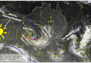
Australian Forecast, Monday June 1st – Looking Mint for Opening Weekend with a Load of Snow in the Nick of Time
Grasshopper's 2026 Australian Snow Season Outlook - May Update
Grasshopper's 2026 New Zealand Snow Season Outlook - El Niño to Favour South Island
Grasshopper's 2026 Australian Snow Season Outlook - El Niño on the way
Weekly North America Forecast, Thursday March 5th – Temps Fluctuate as Storms Favour the North
Weekly Japan Forecast,Thursday March 5th – A Better Week Ahead With More Snow & Colder Temps
Weekly North America Forecast, Thursday, Feb 26th – Canada & Central-Southern Rockies Favoured as Storms Shift North to South
Weekly Japan Forecast, Thursday,Feb 26th – Unconventional Snow in Third Spring-Like Week
Weekly North America Forecast, Thursday February 19h – Powder Tap On Full-Blast as Storms Continue Across the West
Weekly Japan Forecast, Thursday Feb 19th – Powder Day Thursday, Then Spring-Like
Grasshopper's North American 2025-2026 Snow Season Outlook - February Update
Grasshopper's Japan 2025-2026 Snow Season Outlook - February Update.
Weekly Japan Forecast,Thursday February 12th – Less Snow and a Warm Weekend
Weekly North America Forecast, Thursday, February 5th – Tide’s A-Changin’, Snow to Return to the West
Weekly Japan Forecast, Thursday, February 5th – Friday to Monday Storm to Deliver Another Slab of Powder
1
2
3
…
33
Next »