New Zealand Forecast – A Lull in the Action as We Eye a More Promising Outlook
Published early Friday, 17th July 2026
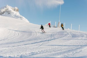
It was an absolute stunner down in the Southern Lakes on Thursday after the ski fields there received a couple of dustings from a pair of passing fronts on Wednesday and Wednesday night. Treble Cone scored a total of 6 cm of fresh powder, The Remarkables 5cm, Cardrona 4cm, and Coronet Peak 2cm, while the snow guns also got some run-time.
However, one of the fronts sparked up some nasty thunderstorms over Canterbury, and some ski fields there copped a downpour that saturated the snowpack, forcing Porters to close for the day on Thursday and delaying the opening of nearby Mt Cheeseman. Mt Ruapehu has also had wet, grey and breezy conditions, with no new snow reported.
Over the next several days, only weak frontal systems will brush New Zealand as they struggle to make any headway into the Roaring 40s, where high pressure is dominating, causing them to fizzle and die upon reaching the country. Ski fields will see a mix of sun, cloud and only light precipitation, resulting in negligible snowfall accumulation.

Friday 17th July
A mostly fine day across Kiwi ski fields with west-to-southwest winds. There’ll just be some cloud over the Southern Lakes, and clouds may affect the lower slopes of Mt Ruapehu.
Saturday 18th July
Brisk west-to-northwest winds bring partly cloudy skies to South Island ski fields, especially the Southern Lakes, where a cold front fizzles before reaching the region at night, with only a sprinkling of snow on the cards. Earlier forecasts had shown potential for more snow from this front, but it hasn’t gone in our favour.
Strong southwesterlies will push cloud into Mt Ruapehu, mostly about the lower slopes, where there could also be a little drizzle at times.
Sunday 19th July
The Southern Lakes should sit in clear air above a deck of low cloud, but there is a chance the cloud will reach some lower slopes at times. Light southwest breezes.
Canterbury ski fields start nice and fine, but they’ll eventually get clagged in as clouds move in due to low-altitude easterlies developing, with a spot of drizzle or flurries also kicking up in the afternoon. Winds at ski field height will be light from the northwest.
Mt Ruapehu will be mostly cloudy with a little drizzle again, while southwest winds gradually ease.
Monday 20th July
A fine, sunny day for the Southern Lakes, with a light south-to-southwest breeze.
Cloud and any drizzle/snow flurries in Canterbury gradually clear as a light northeast breeze turns westwards.
Mt Ruapehu will have light winds, but it’ll be mostly cloudy with a few showers, falling as snow to around mid-mountain.
Tuesday 21st July
South Island ski fields will be fine with some high cloud and west-to-northwest winds.
Mt Ruapehu will be partly cloudy as westerly winds develop.
Extended Forecast
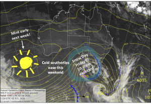
Later next week, from about Thursday, the 23rd of July onwards, stronger storm systems are expected to move in, with a possible late-July boost for the ski fields on the cards. Models aren’t well aligned regarding the actual storm systems, but they’re unanimous that we’ll score some fresh powder before the end of the week and possibly during the week after, too. It’s too early to make any big calls, but it looks promising, so keep the snow dancing up.
That’s all from me today, folks. I’m sending out NZ forecasts every Monday, Wednesday and Friday throughout the season. Have a great weekend, and I’ll see you back here on Monday.
Grasshopper