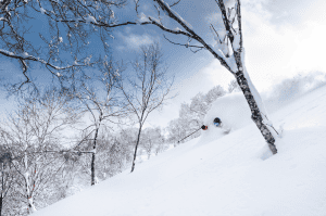
SNOW HOLIDAY
ENQUIRY
Toggle navigation
Forecasts
AUSTRALIA
NEW SOUTH WALES
Thredbo
Perisher
Jindabyne
Charlotte Pass
Selwyn Snow Resort
Victoria
Falls Creek
Mt Hotham
Mt Buller
Mount Stirling
Mount Baw Baw
Lake Mountain Resort
Tasmania
Mount Mawson
Ben Lomond
New Zealand
Queenstown
The Remarkables
Coronet Peak
Queenstown
Wanaka
Snow Farm
Mount Aspiring
Cardrona
Treble Cone
Wanaka
Canterbury
Mount Hutt
Porters
Mount Olympus
Mount Cheeseman
Broken River
Craigieburn
Temple Basin
Hanmer Springs
Mount Lyford
Ruapehu
Whakapapa
Tukino
Turoa
Japan
Hokkaido
Niseko
Rusutsu
Furano
Kiroro
Honshu
Okunakayama Kogen
Hakuba
Nozawa Onsen
Myoko Kogen
Shiga Kogen
Madarao Kogen
Appi Kogen
Shizukuishi
Karuizawa
Mount Naeba
Hakkaisan
Manza Onsen
Hachimantai
Hakkoda
Tazawako
USA
Wyoming
Jackson Hole
Utah
Snowbird
Park City
Colorado
Beaver Creek
Vail
Steamboat
Breckenridge
Aspen Snowmass
California
Palisades Tahoe
Mammoth
Heavenly
Canada
British Columbia
Whistler Blackcomb
Big White
Revelstoke
Sun Peaks
Kicking Horse
Silver Star
Fernie
Alberta
Banff Sunshine
Lake Louise
Europe
France
Val d'Isère
Switzerland
Verbier
Austria
St Anton
Italy
Cortina d'Ampezzo
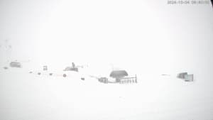
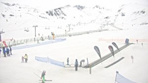
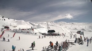
Snow Cams
AUSTRALIA
NEW SOUTH WALES
Thredbo
Perisher
Jindabyne
Charlotte Pass
Selwyn Snow Resort
Victoria
Falls Creek
Mt Hotham
Mt Buller
Mount Stirling
Mount Baw Baw
Lake Mountain Resort
Tasmania
Mount Mawson
Ben Lomond
New Zealand
Queenstown
The Remarkables
Coronet Peak
Queenstown
Wanaka
Snow Farm
Mount Aspiring
Cardrona
Treble Cone
Wanaka
Canterbury
Mount Hutt
Porters
Mount Olympus
Mount Cheeseman
Broken River
Craigieburn
Temple Basin
Hanmer Springs
Mount Lyford
Ruapehu
Whakapapa
Tukino
Turoa
Japan
Hokkaido
Niseko
Rusutsu
Furano
Kiroro
Honshu
Okunakayama Kogen
Hakuba
Nozawa Onsen
Myoko Kogen
Shiga Kogen
Madarao Kogen
Appi Kogen
Shizukuishi
Karuizawa
Mount Naeba
Hakkaisan
Manza Onsen
Hachimantai
Hakkoda
Tazawako
USA
Wyoming
Jackson Hole
Utah
Snowbird
Park City
Colorado
Beaver Creek
Vail
Steamboat
Breckenridge
Aspen Snowmass
California
Palisades Tahoe
Mammoth
Heavenly
Canada
British Columbia
Whistler Blackcomb
Big White
Revelstoke
Sun Peaks
Kicking Horse
Silver Star
Fernie
Alberta
Banff Sunshine
Lake Louise
Europe
France
Val d'Isère
Switzerland
Verbier
Austria
St Anton
Italy
Cortina d'Ampezzo
Snow Reports
AUSTRALIA
NEW SOUTH WALES
Thredbo
Perisher
Jindabyne
Charlotte Pass
Selwyn Snow Resort
Victoria
Falls Creek
Mt Hotham
Mt Buller
Mount Stirling
Mount Baw Baw
Lake Mountain Resort
Tasmania
Mount Mawson
Ben Lomond
New Zealand
Queenstown
The Remarkables
Coronet Peak
Queenstown
Wanaka
Snow Farm
Mount Aspiring
Cardrona
Treble Cone
Wanaka
Canterbury
Mount Hutt
Porters
Mount Olympus
Mount Cheeseman
Broken River
Craigieburn
Temple Basin
Hanmer Springs
Mount Lyford
Ruapehu
Whakapapa
Tukino
Turoa
Japan
Hokkaido
Niseko
Rusutsu
Furano
Kiroro
Honshu
Okunakayama Kogen
Hakuba
Nozawa Onsen
Myoko Kogen
Shiga Kogen
Madarao Kogen
Appi Kogen
Shizukuishi
Karuizawa
Mount Naeba
Hakkaisan
Manza Onsen
Hachimantai
Hakkoda
Tazawako
USA
Wyoming
Jackson Hole
Utah
Snowbird
Park City
Colorado
Beaver Creek
Vail
Steamboat
Breckenridge
Aspen Snowmass
California
Palisades Tahoe
Mammoth
Heavenly
Canada
British Columbia
Whistler Blackcomb
Big White
Revelstoke
Sun Peaks
Kicking Horse
Silver Star
Fernie
Alberta
Banff Sunshine
Lake Louise
Europe
France
Val d'Isère
Switzerland
Verbier
Austria
St Anton
Italy
Cortina d'Ampezzo
Grasshopper
Resorts
AUSTRALIA
NEW SOUTH WALES
Thredbo
Perisher
Jindabyne
Charlotte Pass
Selwyn Snow Resort
Victoria
Falls Creek
Mt Hotham
Mt Buller
Mount Stirling
Mount Baw Baw
Lake Mountain Resort
Tasmania
Mount Mawson
Ben Lomond
New Zealand
Queenstown
The Remarkables
Coronet Peak
Queenstown
Wanaka
Snow Farm
Mount Aspiring
Cardrona
Treble Cone
Wanaka
Canterbury
Mount Hutt
Porters
Mount Olympus
Mount Cheeseman
Broken River
Craigieburn
Temple Basin
Hanmer Springs
Mount Lyford
Ruapehu
Whakapapa
Tukino
Turoa
Japan
Hokkaido
Niseko
Rusutsu
Furano
Kiroro
Honshu
Okunakayama Kogen
Hakuba
Nozawa Onsen
Myoko Kogen
Shiga Kogen
Madarao Kogen
Appi Kogen
Shizukuishi
Karuizawa
Mount Naeba
Hakkaisan
Manza Onsen
Hachimantai
Hakkoda
Tazawako
USA
Wyoming
Jackson Hole
Utah
Snowbird
Park City
Colorado
Beaver Creek
Vail
Steamboat
Breckenridge
Aspen Snowmass
California
Palisades Tahoe
Mammoth
Heavenly
Canada
British Columbia
Whistler Blackcomb
Big White
Revelstoke
Sun Peaks
Kicking Horse
Silver Star
Fernie
Alberta
Banff Sunshine
Lake Louise
Europe
France
Val d'Isère
Switzerland
Verbier
Austria
St Anton
Italy
Cortina d'Ampezzo
Travel
Features
Latest
The Yeti Xtreme Verbier Set To Crown the 2026 Freeride World Tour Champions
World Snow Wrap, March 23rd, 2026 – Powder in Canada, Early Meltdown in US, Dry March in Japan, Incoming Storm for Europe.
Powder Paradise: Winter in Japan's Gunma Prefecture
Freeride World Tour Returns to Alaska with a Freeride Showcase at the Yeti Alaska Haines Pro
Ben Tudhope Claims Second Medal at 2026 Paralympics with Bronze in Banked Slalom
Weather
Weekly North America Forecast, Thursday March 5th – Temps Fluctuate as Storms Favour the North
Weekly Japan Forecast,Thursday March 5th – A Better Week Ahead With More Snow & Colder Temps
World Snow Wrap Feb 27th - Early Spring in Japan, Powder days in Canada and US, Big Storms in Europe
Weekly North America Forecast, Thursday, Feb 26th – Canada & Central-Southern Rockies Favoured as Storms Shift North to South
Weekly Japan Forecast, Thursday,Feb 26th – Unconventional Snow in Third Spring-Like Week
Travel
World Snow Wrap, March 23rd, 2026 – Powder in Canada, Early Meltdown in US, Dry March in Japan, Incoming Storm for Europe.
Powder Paradise: Winter in Japan's Gunma Prefecture
World Snow Wrap Feb 27th - Early Spring in Japan, Powder days in Canada and US, Big Storms in Europe
Weekly North America Forecast, Thursday, Feb 26th – Canada & Central-Southern Rockies Favoured as Storms Shift North to South
Weekly Japan Forecast, Thursday,Feb 26th – Unconventional Snow in Third Spring-Like Week
Events
The Yeti Xtreme Verbier Set To Crown the 2026 Freeride World Tour Champions
Freeride World Tour Returns to Alaska with a Freeride Showcase at the Yeti Alaska Haines Pro
Ben Tudhope Claims Second Medal at 2026 Paralympics with Bronze in Banked Slalom
Freeride World Tour Returns to Haines, Alaska - Competition Confirmed for March 13th
Freeride World Tour Cancels 2026 Fieberbruun Pro De to Unstable Snow Conditions
Mountain Gear
The North Face Basecamp with Wanaka's Aspiring Guides
Gear Review: The North Face Summit Series Verbier Jacket
Win a $2000 Voucher with XTM Performance - Enter Now
Gear Guide: Rip Curl Backcountry Jacket and Pants
Myth-Busters: Ski boot Edition - Buckle up - It's time to Get Your Boots (and facts) Straight.
Chillfactor
World Snow Wrap, March 23rd, 2026 – Powder in Canada, Early Meltdown in US, Dry March in Japan, Incoming Storm for Europe.
Fearlessness: a blade that cuts both ways. New film from Nikolai Schirmer
FreerideWorld Tour, Fiberbruun, Austria, March 5th-10th - Athletes Final Chance to Make FWT Finals
World Snow Wrap Feb 27th - Early Spring in Japan, Powder days in Canada and US, Big Storms in Europe
Australian Team Heads to Calgary for FIS Park and Pipe Junior World Chamionships
Videos
Fearlessness: a blade that cuts both ways. New film from Nikolai Schirmer
Cooper Woods - Road to Milano/Cortina. Video Profile
Harmony - Featuring Sammy Carlson, One of the Best Ski Films of the Year
Josie Baff - Road to Milano. Video Profile
Japan Video Snow Report, January 15th, 2026
Shop Gear
Categories:
Grasshopper
Grasshopper's Japan 2024/25 Snow Season Outlook - December Update
Grasshopper's Weekly North America Forecast, Dec 12th – Storm Cycle Ramps Up with Deep Powder Instore
Grasshopper’s Weekly North America Forecast, December 4th – Quiet, Dry Spell Ends as Storm Rolls Down from the Northwest
Grasshopper's Weekly Japan Forecast, December 5th - First Big Snowstorm of the Season to hit on Friday
Grasshopper's North American 2024-2025 Snow Season Outlook, November Update
Grasshopper’s 2024-2025 Japan Snow Season Outlook, November Update - Potential La Niña but Looking Weaker
Grasshopper's 2024-2025 North American Snow Season Outlook - What La Niña Could Mean for Some of Our Favourite Resorts
New Zealand Weekend Forecast, Friday October 11th – Flakes for the Final Days of the Season
Grasshopper's 2024-2025 Japan Snow Season Outlook - Potential La Niña Could Deliver the Goods
New Zealand Weekend Forecast, Friday October 4th – Wet & Soggy After The Big Dump, Nicer Down South this Weekend
New Zealand Forecast, October 2nd – Rain Turns to Snow as Cold Southerly Sneaks in to Save the Day, Warm Again Tomorrow
New Zealand Forecast Weekend Forecast, September 27th – Chilly Southwesterlies Persist This Weekend with Plenty of Sunshine
New Zealand Forecast, Wednesday, September 25th – Heavy Rain & Strong Winds Thursday into Friday, Followed by a Light Dusting & Icy Temps
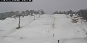
Australian Forecast, Wednesday September 25th – Rain Turns to Snow Wednesday Night, Leaving a Fresh Layer & Sunshine for the Final Days of the Season
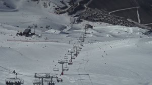
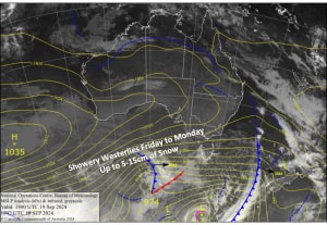
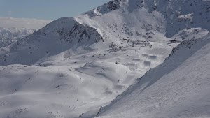
Australian Weekend Forecast, Friday, Sept 20th – A Little More Snow Next Few Days as Cool, Showery Westerlies Continue
New Zealand Weekend Forecast, Friday Sept 20th – Pre-Weekend Top Up Tonight, Then More Snow, Rain and Strong Winds as Spring Westerlies Continue
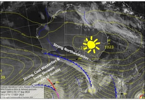
Australian Forecast, September 18th – Strong, Cool Westerlies Bring Snow Showers Thursday through into the Weekend
New Zealand Forecast, September 18th – A Front a Day Brings More Light Shots of Powder
New Zealand Forecast, Monday September 16th – Deep Powder in the Southern Lakes, More Snow for All Kiwi Resorts
Australian Weekend Forecast, Friday September 13th – Winter Creeps Back in a Little Too Late for Most
« Previous
1
…
4
5
6
7
8
…
32
Next »